Barrow, Alaska: Ground Zero for Climate Change
Scientists converge on the northernmost city in the United States to study global warming’s dramatic consequences
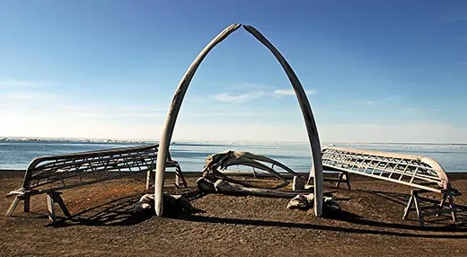
/https://tf-cmsv2-smithsonianmag-media.s3.amazonaws.com/filer/whale-bones-Barrow-Alaska-631.jpg)
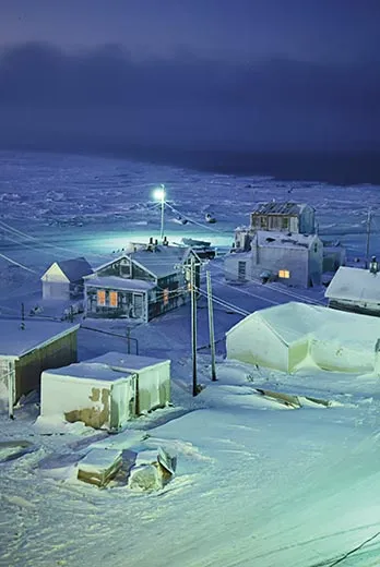
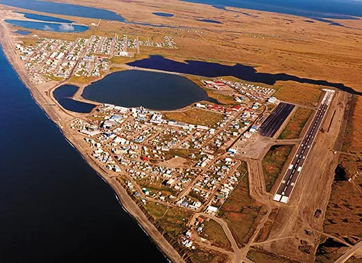
No roads lead to Barrow, Alaska. To reach America’s northernmost city (pop. 4,500), you must fly or, sea ice permitting, take a ship. Barrow’s residents use cars or four-wheel-drive ATVs in town and have been known to hunt caribou on snowmobiles, even in summer. The treads leave dark trails in the tundra, the blanket of spongy brown and green vegetation that stretches south for hundreds of miles. I was coming in on a U.S. Coast Guard C-130 transport plane. Looking down through a small window I saw a triangular-shaped town hugging the edge of the continent at the junction of the Chukchi and Beaufort seas. It was August, and the ocean looked as black as anthracite.
The city’s small wooden homes were built on pilings to keep them from melting the permafrost, which would cause them to sink. I saw jumbles of vehicles, fish-drying racks and small boats in front yards. The roads looked muddy. I saw a large supermarket and a new hospital going up near some office buildings. To the north, along a coast road, I spotted Quonset huts marking my destination—a repurposed World War II-era U.S. Navy base. Concerns about climate change have turned a drizzle of visiting scientists into a flood; I’ve visited Barrow when scientists filled every bed on the former base, bunked ten to a room in a dilapidated house in town and slept in cots laid out in rows in the community center.
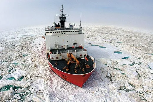
I had come to Barrow to learn about ice and climate change from Eskimo elders and hunters and from scientists. For two weeks I’d been visiting northern Alaska coastal villages as a guest of the Coast Guard, and what I’d heard was disturbing. Each year the sea ice was getting thinner and arriving later. Coastal storms have become so dangerous that some villages—lacking the shore ice that used to protect them—will have to be moved miles inland. In one village I watched the Army Corps of Engineers build rock walls to shield against fierce waves. Fish species from warmer waters were showing up in fishing nets. Insects that no one recalled seeing before—such as spruce bark beetles, which kill trees—were falling from the sky. There was a proliferation of flies that make caribou sick.
Inland, elders told me, tundra lakes were disappearing, and with them drinking water and nesting grounds for millions of migrating birds. River banks—without enough ice to shore them up—were eroding, filling the waterways with silt. When hunters went out after moose, their boats increasingly ran aground in flats.
“It’s harder to find food,” I heard again and again.
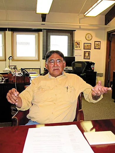
After the C-130 landed, Donald “Nok” Acker of the Barrow Arctic Science Consortium (BASC), a nonprofit research support organization founded by Inupiat Eskimos, picked me up in his mud-spattered Ford truck. I stowed my gear in a dormitory for scientists, and Acker drove me to see Edward Itta, the mayor of North Slope Borough, the largest county (the size of Wyoming) in the United States. Itta is an Inupiat whaling captain as well as a politician who deals with members of Congress, White House officials and military authorities who travel to Barrow for much the same reason I did. His office is in a modern, airy two-story building with new computers and a natural gas heating system, paid for, he told me, by tax revenues from oil fields at Prudhoe Bay. Oil companies there contribute some $250 million a year to the North Slope Borough.
“Barrow is ground zero for climate-change science,” Itta said. “We worry that climate change is shrinking the sea ice and we don’t know how that will affect the animals that depend on it. At this time there is no effective plan if a catastrophe such as a ship collision or oil spill occurs. The Coast Guard hasn’t decided what its presence will be in the Arctic. Someone needs to monitor new traffic as the ice recedes and when tourist ships come through the Northwest Passage, which is already happening.”
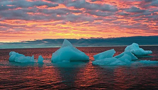
The Arctic is warming twice as fast as the rest of the planet, according to a 2004 Arctic Climate Impact Assessment report, the most recent available. Summer sea ice in the region shrank by nearly 40 percent between 1978 and 2007. Winter temperatures have been several degrees Fahrenheit warmer than they were a few decades ago. Trees have spread into the tundra. In 2008, a wildfire broke out in an area north of the Brooks Range, where the local dialect had no word for forest fire.
Even officials who question the source of the warming are concerned. “I’m agnostic as to the causes,” Coast Guard Commandant Thad Allen told me. “All I know is there is water where there was once ice.” And where there is water, “we are responsible for it.”
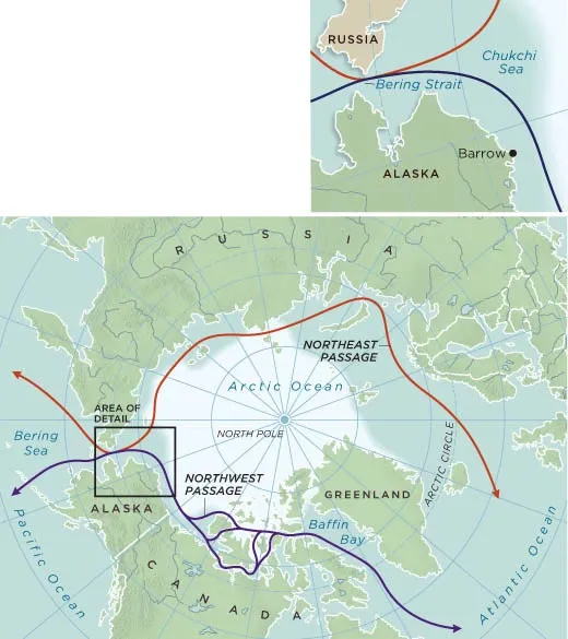
One major consequence is that a new Arctic shipping route around the top of Alaska is expected to open in the next few years, or decades, cutting thousands of miles off trips between Asia and Europe and Asia and the Eastern United States. The fabled Northwest Passage, from Baffin Bay in Eastern Canada to the Pacific Ocean, was frozen for centuries, and attempts to navigate it cost hundreds of European explorers their lives.
But in the past few summers, so much ice has melted that the Northwest Passage actually became navigable. “We’ve never seen ice melt like this in history,” ice forecaster Luc Desjardins of the Canadian Ice Service said in 2008. That summer, two German tourist ships made it through; travel agents are now booking reservations for trips through the passage.
Commercial shipping operations—which abide by different regulations, require more long-term planning and cannot risk having to retreat to the longer route through the Panama Canal—are likely to follow the tourist ships once the passage is more dependably navigable. A single container ship using the route to reach New York City from China could save up to $2 million on fuel and Panama Canal tolls. The passage is expected to open to regular commercial shipping, in summers, sometime between 2013 and 2050. (Icebreakers have enabled the Soviet Union and Russia to use the Northeast Passage, also known as the Northern Sea Route, since the 1930s. When two German commercial cargo vessels made it through last summer, the first non-Russian ships to do so, they made headlines around the world.)
“The [entire North] Alaskan Coast may come to look like the coast of Louisiana today, filled with the lights of ships and oil rigs,” says Scott Borgerson, a visiting fellow for ocean governance at the Council on Foreign Relations.
But the opening of North Alaskan waters to ship traffic poses a host of new challenges for the Coast Guard, which is responsible for security and safety from the Bering Strait to Canada, some 1,000 miles. Security threats along Alaska’s long, unguarded coastline are likely to increase. There may be shipwrecks and fuel spills. “The Bering Strait will be the new choke point for world shipping,” Coast Guard Adm. Gene Brooks told me. “We’re going to have problems.” In recent summers, the Coast Guard has racheted up its visits to Arctic-area villages to learn about the people and operating conditions in the north. It has helicoptered in teams of doctors and veterinarians and held small-boat and helicopter exercises to practice rescue missions. But, Brooks added, “We don’t have the infrastructure: radio towers, communication, all the things that states in the lower 48 have.”
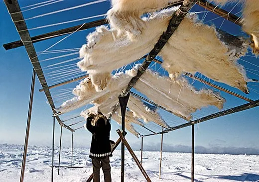
For their part, Alaskan Eskimos worry that the problems associated with increased traffic will affect their food supply. Much of their diet comes from seals, walrus and whales, which may be killed or displaced by human activity. (Packaged food is available but costly. In one town I saw a 16-ounce jar of mayonnaise for $7. A gallon of milk cost $11.) “It is alarming to contemplate the explosion of ship traffic on subsistence hunting and animal migration,” said Vera Metcalf, director of the Eskimo Walrus Commission.
But less ice also spells opportunity. Under a 1982 international treaty called the Convention on the Law of the Sea, Arctic nations can claim sea floor as national territory if they can prove, by mapping the ocean floor, that the areas are extensions of their continental shelves. The implications are staggering because an estimated 22 percent of the world’s undiscovered oil and gas reserves lies beneath Arctic seas, according to the U.S. Geological Survey. Energy and ocean policy consultant Paul Kelly calls the potential expansion “the greatest division of lands on earth possibly ever to occur, if you add up claims around the world.”
The United States, which stands to gain territory the size of California, is woefully behind in the race to develop its territorial claims, critics say. Russia and Norway have already submitted claim applications to a United Nations-based commission that will help determine ownership. Russia and Canada have beefed up their Arctic military forces, and Canada has installed sensors on Devon Island in the high arctic to detect rogue ships.
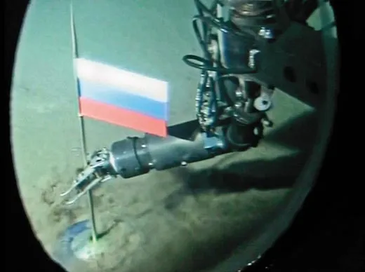
In 2007, Russia dropped a titanium flag on the ocean floor at the North Pole—an act that some have likened in its wake-up effect to the 1957 launch of Sputnik. Artur Chilingarov, the Russian legislator and explorer who dropped the flag, boasted that “the Arctic is ours.” Russia has 18 icebreakers and plans to build floating nuclear power plants for use in the Arctic. In contrast, the United States has two polar-class icebreakers.
In fact, the United States will have little say in the decision to award land claims because some members of the U.S. Senate, citing national security, have blocked ratification of the 1982 treaty for more than two decades. “If this was a baseball game,” Admiral Brooks has said, “the United States wouldn’t be on the field, the stands, even the parking lot.”
“Until now the Arctic was in a frozen state, both literally and figuratively,” Borgerson said. “As it thaws, these new issues emerge.”
“Hold the shotgun and watch out for polar bears.”
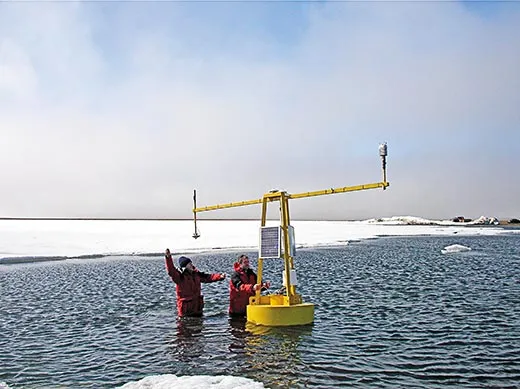
John Lenters pushed a metal boat into a freshwater lake three miles south of Barrow and motioned for me to climb aboard. The wind was stiff, the sun bright, the vista dotted with Arctic flowers—marsh marigold and Arctic cotton. Lenters, a hydroclimatologist at the University of Nebraska, studies how tundra lakes are responding to climate change. Now he was steering toward a yellow speck in the middle of the lake, a climate-monitoring buoy due for scheduled maintenance.
The tundra is a vast watery wilderness filled with snaking rivers and tens of thousands of elliptically shaped lakes supporting moose, caribou and polar bears. From the air, with its clouds and mist, it looked, oddly enough, more like the Amazon basin than the desert that one of Lenters’ colleagues called it and by some definitions it is. (Lenters himself says only that “precipitation is slight.”) But what precipitation there is, Lenters explained, is prevented from seeping into the soil by permafrost, the layer of frozen earth that begins about two feet beneath the surface and goes down, in North Alaska, some 2,000 feet. Globally, permafrost holds an estimated 400 gigatons of methane, one of the greenhouse gases that is hastening the earth’s warming. As the permafrost thaws—which it has begun to do—lakes can drain away and the thawed soil can release billions of tons of methane into the atmosphere.
Lenters pulled up to the buoy and, balanced on the prow of the boat, began wrapping duct tape around some of the buoy’s wires to protect them. “This is the grunt work of science,” he said. A swiveling arm on the buoy measured wind speed. Solar panels on its three sides provided power. A glass-domed instrument on top registered incoming infrared radiation to monitor the greenhouse effect—the rise in temperature that results from the trapping of heat by certain gases, such as carbon dioxide, in the atmosphere.
Lenters said that he and other researchers—aided by decades-old satellite images as well as consultations with Inupiat—are visiting tundra lakes all over the area, walking their perimeters and measuring their size, water depth and temperature. “Everything up here is related to climate change,” Lenters said, “but to understand it you must learn the underlying dynamics.”
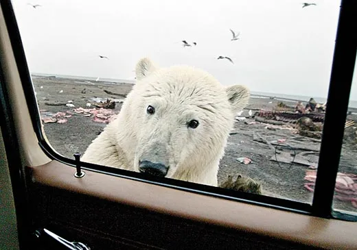
In his camouflage clothes and waders, Lenters looked like a deer hunter as he jury-rigged repairs and took measures to protect the buoy from various assaults over the next ten months. Windblown chunks of ice might partially submerge it, and once the lake freezes over, a curious Arctic fox might nibble on its wires. While tending the buoy last year, Lenters spotted two polar bears a quarter-mile away swimming toward him. Bears are an ever-present concern. Guards with shotguns sometimes stand watch at high- school football games. (While I was in Barrow, a bear wandered past BASC headquarters. Another took pieces out of a scientist’s boat; no one was inside.) While Lenters worked, I scanned the horizon.
Lenters said that while he’d collected only about a year’s worth of data, he’d already been surprised by it. Typically, he said, lake beds release as much heat into the water in the winter and spring as they absorb in the summer and fall. This balance keeps the annual sediment temperatures fairly stable. “But what we found was that heat was going into the lake sediment almost all year long.” It’s too soon to draw any firm conclusions, he added, “but the water temperatures are out of equilibrium with the lake sediment, causing a nearly continuous thawing of the underlying permafrost. The lake is out of whack.” Then he turned the boat around and we headed back to town for some hot soup.
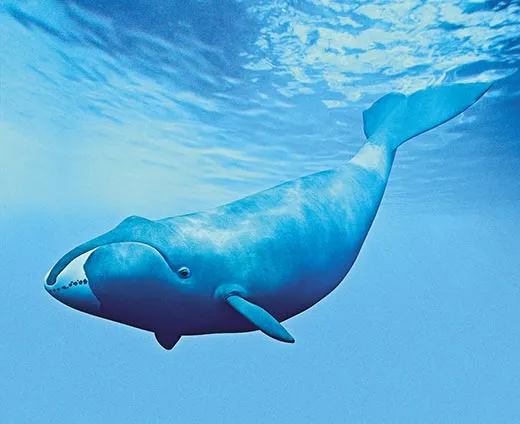
Bowhead whales are named for the massive bony skulls that enable them to break through ice to breathe. They can live up to 200 years; adults weigh up to 100 tons. Their biannual migrations between the Bering Sea and the Eastern Beaufort Sea carry them past Barrow each fall and spring. “The whale is central to our culture,” Mayor Itta had told me. “The warmer ocean and currents will markedly shorten our spring whaling season.” He was concerned about possible changes in whale migration patterns and sea ice conditions; hunters must travel over ice to reach whales. “The impacts are around us already. We need more baseline science so we can measure these impacts over time.”
Which was one reason that—about 20 miles out to sea—Eskimo whalers and researchers aboard three small boats rode the chop, looking to tag bowheads with radio devices. Mark Baumgartner, a biologist from the Woods Hole Oceanographic Institution in Massachusetts, was looking for answers to the same questions as the whalers with him. “We think the environment is going to change,” he said. “We don’t exactly know how. This is part of a study to learn how the animals forage and how food is organized.” If warming seas cause the whales’ preferred foods to move, the whales could follow—with disastrous consequences for Eskimos.
Carin Ashjian, another Woods Hole biologist, was on a sister ship, the 43-foot-long Annika Marie, studying krill, a shrimplike animal that bowheads eat. Massive amounts of krill pile up on the continental shelf off Barrow each year in the fall. The krill are pushed by sea currents and wind, both of which can be affected by weather patterns. “We want to know whether there will be more or less krill with climate warming,” Ashjian explained. She said her five-year-old study was still too new to yield any firm conclusions: “The Arctic is changing so fast that when it comes to learning basics, we may have started too late.”
In a third study relating to bowheads, Kate Stafford, an oceanographer at the University of Washington, had come to Barrow to service the hydrophones, or undersea microphones, she’d put in the water a year before. She was monitoring sounds—from waves, marine mammals, the breaking of ice and the passing of ships.
“Marine mammals use sound to communicate and navigate,” she said. “When the water is covered with ice it’s pretty quiet down there. During spring breakup it gets noisy. If the ice becomes thinner in winters or goes away, it may become more difficult for animals to communicate.”
Shell Oil representatives, in town for hearings on proposed exploratory drilling in the Chukchi Sea, are also interested in bowheads. Shell’s attempts to drill in the Beaufort Sea were blocked by a court injunction in 2007, when a coalition of environmentalists, native groups and the North Slope Borough filed suit. The coalition cited the effects on marine mammals, particularly bowhead whales, from the drilling. (The company has approval from the Interior Department to drill this coming summer, but environmental and native groups are challenging the plan.)
Concerns about whales go to the heart of the relationship between scientists and Barrow residents. In 1977, the International Whaling Commission, citing studies showing that bowheads were an endangered species, banned Eskimo whaling on the North Slope. But Barrow residents said they had seen plenty of bowheads, and their protests led to new research on whales’ population. The ban was replaced by a quota after six months.
Richard Glenn is a whaler and businessman, and vice president of the Arctic Slope Regional Corporation (ASRC), a for-profit organization owned by Inupiat shareholders. Along with other community leaders, Glenn helped found BASC, which offers scientists laboratory space, cellphones, a support staff and an environment where researchers often end up collaborating on studies.“This is a town of ice experts,” Glenn told me. “Our job is to have a running inventory of conditions. Put that together with science and the cultural differences disappear. It becomes like two good mechanics talking about a car.”
Back in 1973 the National Oceanic and Atmospheric Administration (NOAA), the federal agency responsible for predicting changes in the earth’s environment, selected Barrow as one of five key spots on the globe to make atmospheric baseline studies. “We wanted places that were far removed from large industrial sources of gases yet not so remote that they’re impossible to get to,” said Dan Endres, who ran the agency’s Barrow facility for 25 years until 2009.
Today, sensors in NOAA’s Barrow observatory—basically a set of trailer-like buildings filled with scientific equipment, perched on pilings over tundra—sniff the air for ozone, carbon dioxide, other gases and pollution, some of which comes from Chinese factories thousands of miles away. In summer, carbon dioxide is absorbed by boreal forests in Russia and Canada. In autumn, the vegetation dies and the carbon dioxide is released back into the air. This oscillation is the largest fluctuation on earth and has been likened to the planet breathing.
Inside one trailer, John Dacey, a Woods Hole biologist, was installing equipment to measure dimethyl sulfide, a gas scientists use to track the formation of particles called aerosols in the atmosphere. “Much like ice or snow, aerosols can reflect the sun’s heat back to space,” said NOAA research scientist Anne Jefferson. In other cases, “like a dark ocean surface, they can absorb the sun’s heat.” Jefferson was calibrating instruments for monitoring clouds and aerosols, part of a study of the role these factors play in warming and cooling.
Based on research undertaken at Barrow, we now know that the yearly average of carbon dioxide in the atmosphere increased in the Arctic by 16 percent between 1974 and 2008 and that methane increased an average of 5 percent between 1987 and 2008, according to Russ Schnell, deputy director of NOAA’s global monitoring division. The snow melts about nine days earlier in the year than it did in the 1970s.
Snow and ice help explain why “a small change in the temperature in the Arctic can produce greater changes than in lower latitudes,” said Endres. Snow reflects sunlight; once it melts, more energy is absorbed by the earth, melting even more snow. “Whatever is going to happen in the rest of the world happens first and to the greatest extent in the Arctic,” said Endres. “The Arctic is the mirror of the world.”
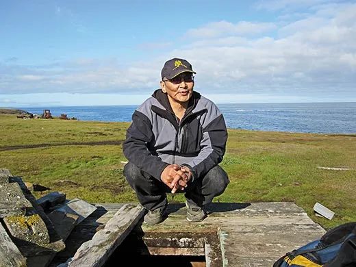
Chester Noongwook, the last dog-sled mail carrier in the United States, is 76 years old and retired. He recently survived a brain aneurysm, but he looked strong and alert when I met him in Savoonga, a village of about 700 people on St. Lawrence Island, a 90-mile-long collection of mountains and tundra in the Bering Sea. Noongwook, who still hunts whales, showed me a book he co-authored, Watching Ice and Weather Our Way, which records Eskimo observations of the natural world. Then he gave me a lesson in the language of ice.
Maklukestaq, he said, is a Yupik Eskimo word for solid, slightly bumpy ice, capable of having a boat pulled across it. There is less maklukestaq of late. Ilulighaq refers to small- or medium-sized cakes of ice, big enough to support a walrus. Nutemtaq—old, thick ice floes—are safe for a seal or whale hunter. Tepaan is broken ice blown by wind against solid ice, dangerous to walk on.
In all, the Yupik language has almost 100 words for ice. Their subtle variations, passed down verbally over thousands of years—no written Eskimo language existed until about 100 years ago—can mean life or death for those who venture over frozen ocean, tundra lake or river. Elders are repositories of knowledge. Their photographs hang in schools, like those of presidents in the lower 48. But in some places, I was told, conditions have changed so much that elders have begun to doubt their ice knowledge.
“The world is spinning faster now,” Noongwook said, by which I took him to mean that the weather, and the ice, have become less predictable.
Chester’s son Milton Noongwook, 49, is the former secretary of the local tribal council. Showing me around Savoonga in an ATV, at one point he pulled out a Sibley Field Guide to the birds of North America. He said so many new kinds of birds are showing up, villagers need a guidebook to identify them.
As we drove up to the shore, Milton pointed to a series of large wooden boxes set deep into permafrost to store frozen walrus meat—winter food. He pulled aside a door and in the dark below I saw hunks of meat amid a sheen of frost. But it was also wet down there.
“It’s melting,” Milton said. “It never used to do that. If it gets too warm, the food will spoil.”
Back in Barrow, I got a ride with a taxi driver from Thailand. “I’m here because I love snow,” he told me. I ate dinner at Pepe’s North of the Border Mexican restaurant. At midnight I found myself at a roller rink where a rock band, the Barrowtones, performed for people who might have been tagging bowheads earlier in the day.
On my last day, Richard Glenn took me in a small boat to the junction of the Chukchi and Beaufort seas. Seals popped up in the water. Glenn watched the sky, ready to turn back if the weather grew rough. We chugged through three-foot swells to Point Barrow, the northernmost tip of the North American continent. On the beach, orange ribbons marked an ancient burial ground. After a skeleton was found in 1997, community elders gave permission for Anne Jensen, an anthropologist with the Ukpeagvik Inupiat Corporation, which handles village land titles, to dig up the remains of the other 73 burials and, with help from Barrow high-school students, move them to Barrow’s cemetery.
Glenn said that although there was no ice visible at the moment, it would soon begin to form. He spoke of it with love, the way a Vermont hiker might discuss leaf color in October or an Iowa farmer goes on about corn. Glenn said that one day, a few years back, he’d watched the sea go from liquid to ice in the course of a 12-mile hike.
Some time around October, he said, the waves now lapping against the shore would turn to slush, like “an unflavored Slurpee.” Then, as temperatures dropped, the slush would congeal and become rigid. Colder still and the ocean would break against itself and form mountain ranges of ice “like plate tectonics on a smaller scale.” Snow would cover it, and in spring the ice would weaken. “You can notice it and smell it. The animals know it.” Finally, the whales, seals and ducks would start to come back to Barrow.
That’s the way it always happened. That’s the way it was supposed to happen. As the worsening weather closed in, Glenn turned the boat back to shore. He wasn’t worried, he said. He would cope with climate change just as he’d coped with other changes he’d seen. “We may have to learn some new weather patterns,” he said. “But we always have.”
Bob Reiss is a New York City writer. His book The Coming Storm chronicles events related to global warming.
