Satellites Spot Whales From Space
This new method could help researchers remotely count and keep track of whale populations
:focal(375x109:376x110)/https://tf-cmsv2-smithsonianmag-media.s3.amazonaws.com/filer/4d/73/4d73a472-7561-45d2-9ca4-73554df7355f/whale.jpg)
Counting tends to be at the base of any ecological study. Knowing how many animals and of what kinds live in a particular habitat is essential for understanding the relationships between them. That knowledge also allows scientists to quantify how certain species' populations change through time and to extrapolate how an environment and the species within it may changes in the future. This is especially important for determining whether management or conservation efforts need to be adjusted.
Finding out how many animals exist in a particular place, however, varies in difficulty. For ocean-dwelling creatures, this task becomes even harder given that the ocean is so large and is quite good at concealing animals within its depths. Even huge mammals such as whales, which spend a significant portion of their time at the ocean surface, prove difficult to count. Oftentimes, counts are restricted to a single person standing on land or on a ship platform with a pair of binoculars, or flying overhead in a small plane, doing his or her best to spot the elusive whales.
“Whale populations have always been difficult to assess,” said Peter Fretwell, a researcher at the British Antarctic Survey, in a statement. “Traditional means of counting them are localized, expensive and lack accuracy.”
But what if this task could instead be automated and conducted over a large area of ocean all at once?
Fretwell and his colleagues at the Survey realized that, at least for whales, very high resolution satellite images might provide a useful shortcut for counting those animals. Although a few past studies have turned to satellites as a possibility for surveying whales, those efforts haven’t produced much success, mostly because the images were not very refined. But recent advances in imaging resolution and accuracy, the team thought, might be enough to make renewed surveying attempts a success.
They decided to put this idea to the test in a bay off the coast of Argentina’s Peninsula Valdes, where southern right whales gather to breed. Thanks to bans on whaling, those previously endangered animals seem to be increasing in numbers, but no one knows the right whales’ actual population size.
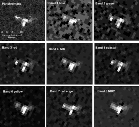
In a study published today in PLoS One, the researchers analyzed a single image taken by WorldView2, a satellite capable of imaging at extremely high resolutions. The WorldView2 image they acquired surveyed a 40 square mile area of ocean and provided imagery that penetrates deeper into the water column than other satellites currently deployed. The image was broken down into eight color bands with an on-the-ground resolution of about two meters per pixel and a panchromatic band with an on-the-ground resolution of 50 centimeters.
To spot the whales, the team first surveyed the images manually and then used image-processing software that employed a whale-recognizing algorithm they wrote. Both the software and the researchers narrowed potential whales down by asking three questions: Is it the right size and shape to be a whale? Is it in a place where a whale is expected to be? Are there other objects floating around or a fuzziness to the image that might mean what looks like a whale is actually just bubbles, a rock or birds?
From those images, the researchers identified by hand what they were fairly certain was 55 whales, along with 23 other objects that they suspected were whales. They also spotted an additional 13 possible whales under the surface. They found the best results for spotting those hidden whales lurking beneath the waves in the satellite's fifth band, in the violet end of the light spectrum (400 to 450 nanometers).

The computer succeeded in identifying 89 percent of whales that the researchers had pinpointed by hand in the images. However, the computer had a 24 percent false-positive rate, meaning that it classified things as whales that the researchers determined were not whales, such as boats. The idea is to eventually improve that algorithm’s accuracy, to make whale surveys a nearly automated task.
This study is a proof of concept work—one that introduces a potential new method. The team points out that they will still need to do on-the-ground surveys to see whether the satellites might be missing any whales, or might be biased toward or against detecting some whales over others (for example, mothers with calves sometimes appear as a confusing blob rather than distinct whale outlines). On-the-ground comparisons of what seems like a whale in a satellite image to what is actually swimming in the ocean will further validate the method.
“The next challenge is to determine detection probabilities and understand whether counts from images can be used as a reliable index for population size, or presence,” the authors write. “This paper shows that automated analysis of satellite imagery can achieve a good match with manual counts, but more work is needed to ensure that these manual counts are commensurate with the real number of surface whales.”
Having several satellite images taken in succession could help identify what is truly a whale and what is a stationary rock or dissipating wave, they add. They also write that the method works best in calm water free from waves, which, for the time being, limits its applicability. In addition, it helps to know where where whales are likely to be, as in the case study presented in the paper.
If the method does prove viable, then the authors think it could be used not only to help estimate and monitor right whale populations, but also to take head counts of other whale species. As higher quality satellite imagery becomes available in the future, surveying whales from space will hopefully become an even more accurate and useful tool in the conservationist’s belt, the researchers write.
/https://tf-cmsv2-smithsonianmag-media.s3.amazonaws.com/accounts/headshot/Rachel-Nuwer-240.jpg)
/https://tf-cmsv2-smithsonianmag-media.s3.amazonaws.com/accounts/headshot/Rachel-Nuwer-240.jpg)