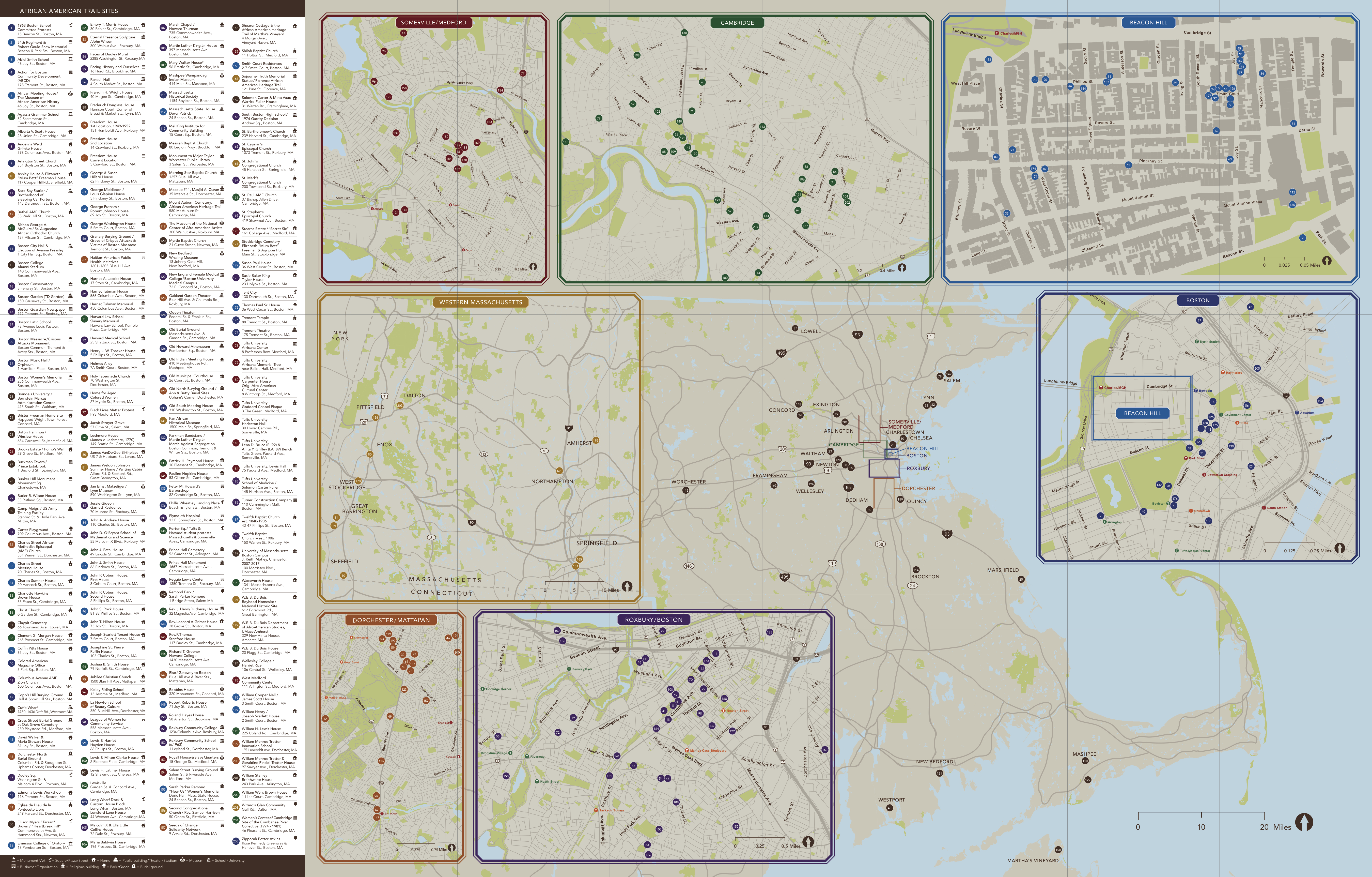
This Map Details More Than 200 Massachusetts Sites Connected to African-American History
You can contribute to the project by suggesting new entries or proposing edits to existing ones via the project’s main hub
/https://tf-cmsv2-smithsonianmag-media.s3.amazonaws.com/accounts/headshot/mellon.png)
/https://tf-cmsv2-smithsonianmag-media.s3.amazonaws.com/filer/96/15/96156d34-3ecd-4984-9d68-0352a9ff2e1a/4048163507_274c2b04a7_b.jpg)
A public history initiative spearheaded by faculty and students from Medford’s Tufts University is mapping hundreds of sites linked to more than 350 years of black history in Massachusetts.
According to the African American Trail Project’s website, the campaign—inspired by the research of Tufts historian Gerald R. Gill, who died in 2007—aims to “develop African American historical memory and intergenerational community” through the juxtaposition of contemporary movements such as Black Lives Matter and centuries-old history. (Did you know, for instance, that Massachusetts holds the jarring distinction of being both the first North American colony to legalize slavery and the first state to list no enslaved individuals in its 1790 filing for the inaugural federal census?)
Kendra Field, director of the university’s Center for the Study of Race and Democracy, and co-project leader Kerri Greenidge have partnered with historical groups across the greater Boston metro area, as well as fellow faculty, students and staff to build the database, which Tufts Now reports was initially launched in 2017 with a catalogue of around 115 entries.
Users can browse through the sites, which now number in the 200s, via a dropdown menu or randomly clicking through clusters of purple markers. Each entry features an address, brief history, photograph and links to further information, Katharine Q. Seelye details for The New York Times.
An accompanying online portal highlights specific sites from the 17th through 21st centuries, while a PDF map offers an alternative overview of selected locales by breaking down the list into an array of categories: monuments or works of art, businesses and organizations, streets and plazas, religious buildings, homes, public buildings, museums, schools, and burial grounds.
The project aims to draw attention to Massachusetts’ rich African-American historical legacy, which Field points out can often be framed reductively: Boston, for instance, is sometimes viewed as a place “where fugitive slaves came and were ‘rescued’ by the abolitionists, or … where people were throwing bricks at black children” during desegregation protests in the 1970s. The map is a way to interrogate those simplified narratives.
“We wanted to make the history more visible and the facts accessible,” Field tells The New York Times’ Seelye.
Amongst the earliest sites spotlighted by the initiative are the Dorcester North Burying Ground, a 17th-century cemetery where two enslaved children named Ann and Cambridge, and one enslaved woman named Betty, were laid to rest, and the Zipporah Potter Atkins Site, which once hosted a house purchased by the eponymous Atkins, a free woman who was one of 17th-century Boston’s only black homeowners, in 1670.
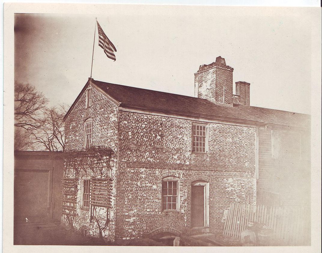
Moving to the 18th and 19th centuries, Tufts Now highlights the Royall House, a Medford estate dating to 1737 that hosts the northern United States’ only surviving slave quarters, and the African Meeting House, which was mainly built by black laborers and became a meeting hub for Boston’s free African-American community. Also of note is a plaque commemorating the 1761 purchase of a seven- or eight-year-old girl taken from her home country of Senegal. Named Phillis after the ship upon which she’d arrived, she would become known as Phillis Wheatley, one of the most renowned poets of her time.
The New York Times’ Seelye outlines several additional points of interest: There’s the grave of Harriet Jacobs, an escapee who spent seven years hiding from her abusive master before going on to produce a memoir titled Incidents in the Life of a Slave Girl, Written by Herself, and the “Faces of Dudley” mural, which portrays former residents of Boston’s Roxbury neighborhood. Amongst the individuals depicted in the work are Malcolm X and Melnea Cass, a suffragist and civil rights activist.
More historical figures will be joining the ever-growing digital map as the project continues on. And if you have a place in mind, you can participate by suggesting new entries or proposing edits to existing ones via the project’s main hub.
/https://tf-cmsv2-smithsonianmag-media.s3.amazonaws.com/accounts/headshot/mellon.png)