What We’re Still Learning About Hawaii
The fiery forces beneath the island chain still mystify geologists
/https://tf-cmsv2-smithsonianmag-media.s3.amazonaws.com/accounts/headshot/science-erin-wyman-240.jpg)
/https://tf-cmsv2-smithsonianmag-media.s3.amazonaws.com/filer/Hawaiian-islands-631.jpg)
Haleakala originated as a vent on the seafloor about two million years ago. Eruptions of lava built up the volcano until it reached the sea surface less than a million years later; continued eruptions pushed it more than 10,000 feet above sea level and gave it almost 600 square miles of land. Haleakala eventually connected with another volcano to form the island of Maui. In fact, all the Hawaiian Islands are of volcanic origin.
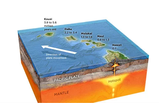
Most volcanoes—Mount St. Helens, say, or Mount Fuji—grow along the boundary between tectonic plates, where collisions melt the earth’s upper layers and fuel eruptions. By contrast, Hawaii’s volcanoes emanate from a “hotspot” under the Pacific plate.
The hotspot, which geologists estimate began producing the Hawaiian Islands 30 million years ago, is a plume of molten rock that rises through the mantle, the mostly solid layer between the crust and core. The islands were formed as the Pacific plate crept northwest at three to four inches a year, carrying volcano after volcano away from the stationary hotspot like a conveyor belt.
Though scientists have zeroed in on the hotspot as the source of Hawaii’s volcanoes, there’s still a lot they don’t know about it, including just how deep it is. Many scientists estimate that the hotspot originates some 1,800 miles into the earth, near the boundary between the mantle and the planet’s iron-rich core. In one recent test, researchers led by the University of Hawaii measured how fast seismic waves from earthquakes travel below ground—the waves move more slowly through hot rock than cold—and traced one plume under the Big Island of Hawaii that extends at least 900 miles deep. However, MIT scientists found a source only 400 miles beneath the surface, a 1,200-mile-wide reservoir of hot rock west of the Big Island.
Figuring out how to see into the earth’s interior is “just a very difficult experimental problem to answer,” says John Tarduno, a geophysicist at the University of Rochester in New York. “We would like to get better images to see the hotspot source itself.”
The islands don’t last forever. As the Pacific plate moves Hawaii’s volcanoes farther from the hotspot, they erupt less frequently, then no longer tap into the upwelling of molten rock and die. The island erodes and the crust beneath it cools, shrinks and sinks, and the island is again submerged. Millions of years from now, the Hawaiian Islands will disappear when the edge of the Pacific plate that supports them slides under the North American plate and returns to the mantle.
For now, Haleakala is hanging on. The volcano last spewed lava sometime between 1480 and 1780, but it has erupted more than 12 times in the past 1,000 years. Another eruption is not out of the question, says Richard Fiske, a geologist emeritus at the Smithsonian National Museum of Natural History. Says John Sinton, a geologist at the University of Hawaii at Manoa: “It’s a volcano that has refused to die.”
/https://tf-cmsv2-smithsonianmag-media.s3.amazonaws.com/accounts/headshot/science-erin-wyman-240.jpg)