Where Lance Remains the King
Among the peaks, cirques and summits of the French Pyrenees, the greeting call to an American on a bike may always be “Armstrong!”
/https://tf-cmsv2-smithsonianmag-media.s3.amazonaws.com/filer/20120531101024TourCountryTeamWithAllySMALL.jpg)
When I toured Greece in 2006, locals who learned I was American would often bark “Bush!” When I went to Turkey in 2011, that bark had lost its bite and become the cheer of “Obama!”
But where I am now, among the peaks, cirques and summits of the French Pyrenees, the greeting call to an American on a bike may always be “Armstrong!” For it was the American hero cyclist who dominated these mountains seven years in a row beginning in 1999. Though other champion cyclists have since replaced Lance Armstrong as winners of the Tour de France, the lanky American’s name still resounds among locals—and remains spray-painted on the asphalt in places, especially near the summits of the big passes and the mountaintop stage finish lines where fans and spectators grow nearly dizzy with excitement each July.
When I discovered last week that I was smack in the hilly heart of the Pyrenean Tour de France route, I had no choice: I would have to make every climb that Armstrong, Alberto Contador, Andy Schleck, Levi Leipheimer and hundreds of other pros have made—only my legs aren’t shaved, I’m dragging 40 pounds of gear and no one makes me wear a polka-dotted jersey when I reach the summit. Here are a few of the more astounding ascents.

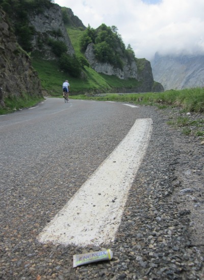
One way to know you're on the trail of the Tour de France is the abundance of discarded energy food wrappers and tubes, like this one on the long climb to Col du Soulor. Photo by Alastair Bland.
Col du Soulor, summit at 4,724 feet (1,474 meters). One of the oldest climbs in the Tour, the ascent from the village of Ferrieres to the pass takes cyclists more than 1,600 feet straight up. I pedaled this one just after coming over the lesser known Col de Spandelles, and my legs were already warm from the effort. Teams of men and women on 18-pound bikes powered past me, their shirt pockets bulging with candy bars and their discarded trash trailing behind them along the roadside. Near the bottom of the ascent, a sign tells passersby that this road has been a part of the Tour de France since 1910, when pro cyclists had never heard of SAG (support and gear) vehicles and when they probably ate bread and cheese en route. When I arrived on top, it was a circus. I got there alongside a team of racers from Corsica—La Stella Burghisginana was their name. Giddy as schoolboys, several took turns pedaling circles on my loaded bike as the rest gathered by the pass marker for a photo. They invited me to sit in for the picture, then they dashed away for the next pass. I stayed a while and ate a hunk of cheese.
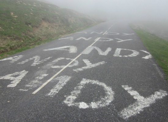
Col d’Aubisque, summit at 5,610 feet (1,709 meters). This monster straddles the mountains just seven kilometers west of Soulor, so it’s no surprise that the two passes have occurred within the same stage of the Tour de France. The ride between the two, though short, is glorious—a narrow highway carved almost ludicrously into the cliff along a cirque of peaks. Close to the summit of Col d’Aubisque, the name “Andy” appears repeatedly in spray paint on the asphalt—because someone out here apparently is mad for Andy Schleck. (Further toward the top is the message, “WILL YOU MARRY ME?”) Note: I stashed a beer halfway between the two passes, in the cliff. It’s a Kellegen blond special, 8.6 percent alcohol, stuffed into a hole in the left end of the cobblestone retaining wall. On the wall is spray-painted a Basque freedom message, “LIBERTAT.” You can’t miss it.

On the road to Col d'Aubisque, cyclist Andy Schleck sees his name in spray paint. Photo by Alastair Bland.
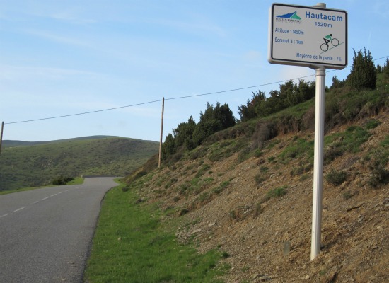
Hautacam, summit at 4,933 feet (1,520 meters). A beast of a climb, and a beauty, the road to the Hautacam ski resort runs 13 kilometers, hits a 10-percent grade in parts, has been a finishing point in four Tours and takes cyclists more than 3,300 feet closer to the sun. Along the way, messages of cheer meet cyclists addressed personally by name, as on almost all the great Tour climbs. Unlike the madhouse on top of Soulor, Hautacam was deserted. I camped on the green slope just above the finish line. The songs of sheep and horses and the clatter of their bells welcomed the stars of the night sky, and the clamor and confusion that come in July as the pros arrive was a phenomenon I could only imagine—or come back and see. Note: I left a bottle of something extra special just 2.2 kilometers from the top, under a table-like rock on the left side of the road, 200 meters past a roadside auberge, and just 20 meters past a metal grate over the road. Email me when you find it.

On many of the Tour de France climbs, kilometer markers that may aggravate or encourage cyclists line the road. This one tells cyclists that the summit of Hautacam lies just 1,000 meters ahead. Photo by Alastair Bland.
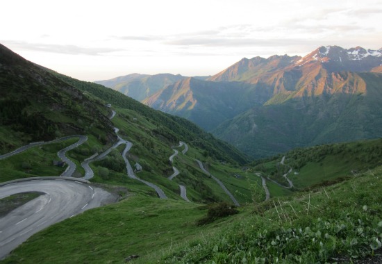
Luz Ardiden, summit at 5,643 feet (1,720 meters). Lance Armstrong may have been king of these mountains year in and year out, and he wore a polka-dotted cycling jersey to prove it, but Luz-Ardiden wears the crown. On this mountain there’s no hidden beer that I know of, but it’s an uphill haul so sweet, so sensational and so wonderfully surrounded by higher peaks and passes that it would be worth hauling a bottle of Champagne to the summit and blowing the cork into the void. Seven renditions of the Tour have included a finish line on this mountain, whose highway gradient averages 7.6 percent and climbs more than 3,400 feet. At the bottom, in the river gorge town of Luz-Saint-Sauveur, the cyclist is surrounded by sky-high craggy summits that require craning the neck to have a look—but turn by turn, the top of the world drops until you’re up among the snow, the clouds and the champions of cycling. The final three miles of this climb are as dramatic and spellbinding a ride as one could ask of a mountain range—a series of switchbacks cutting straight up a mountainside as green as Scotland, with stone shepherd huts built into the slopes. On top is the downside—a ski station, the ugliest offense after a clearcut that people can inflict on a wilderness place. But I arrived at 9 p.m. on a late-spring evening—and I’ll admit that a ski resort without a soul on the premises is a strangely beautiful thing.

The view looking down from the summit of Luz-Ardiden, one of the greatest climbs of the Tour de France. Photo by Alastair Bland.
Col du Tourmalet, summit at 6,369 feet (2,115 meters). The highest paved road pass in the region, it may also be a disappointment for many cyclists. The road to Tourmalet is a thoroughfare on which trucks, RVs and pods of touring motorcycles thunder past almost nonstop. The views are grand, but coming up from either side (I came from the west) you’ll pass ski resort after ski resort, their cables and egg pods still as the trees but ugly as electrical towers. Note: There’s a beer on top. If you’re coming up from the east side, you’ll see a concrete bunker-like structure on the right side of the highway. It’ll just take you a second; jump off the bike, reach under the ground-level ledge (you’ll see what I mean), and find the beer. I left it directly beneath the “L” in the spray-painted political message about Basque freedom. Go get it—but drink it after you descend from this enormous pass.
Col d’Aspin, summit at 4,883 feet (1,489 meters). From the west, Aspin is a quiet, gentle grade, through pine forest almost all the way, and you may hear the red deer roar if you stop to listen. On top, I was alone—and it was all cows, the orange light of sunset and discarded energy bar wrappers. I was weary of heights and hills by now—and of graffiti messages for Andy Schleck and Alberto Contador—and I gladly dropped down the east side to find a place to sleep. It was dramatically steeper than the west and 800 meters to the base, and—this once, anyway—I was glad I wasn’t going up.
For more information on great cycling in the Pyrenees, consider this book, Best Cycling Routes of the French Pyrenees.
Planning Your Next Trip?
Explore great travel deals
Smithsonian magazine participates in affiliate link advertising programs. If you purchase an item through these links, we receive a commission.
/https://tf-cmsv2-smithsonianmag-media.s3.amazonaws.com/accounts/headshot/Off-Road-alastair-bland-240.jpg)
/https://tf-cmsv2-smithsonianmag-media.s3.amazonaws.com/accounts/headshot/Off-Road-alastair-bland-240.jpg)