Mini-SAR nears completion of its first mapping cycle

The Mini-SAR imaging radar aboard the Indian Chandryaan-1 spacecraft currently orbiting the Moon has been sending back some amazing images for the last couple of months. We are nearing the end of our first radar mapping season (which occurs when the sun illumination conditions on the Moon are unfavorable for normal surface or mineral mapping) and I think it’s an appropriate time to look at and evaluate the data in hand.
To refresh your memory, Mini-SAR works by sending radio pulses to the Moon from the orbiting spacecraft and then very precisely recording the radio echoes bounced off the surface along with their timing and frequency. From this information, we construct images of the Moon that not only show the terrain in areas we could not otherwise see, such as permanently shadowed areas near the pole, but also contains information on the physical nature of the surface covered, specifically, the presence of terrain with unusual scattering properties. Such properties can be caused by many different things, such as composition, particle size, and physical configuration. Most famously, radar reflections can indicate the presence of water ice, based upon the distinct signature of planetary polar caps and the icy moons of Jupiter.
Typically, radar instruments are very massive and use copious amounts of power, but Mini-SAR is less than 10 kg (22 lbs.) and uses less power than the reading light in your living room. It does, however, generate large amounts of data and only a certain amount can fit in the data recorder aboard the Chandrayaan spacecraft. As imaging cameras and spectral instruments also produce large data volumes, we operate Mini-SAR during times when it does not compete against these instruments. Fortunately, because radar imaging provides its own illumination, we do not need the Sun and all of Mini-SAR’s operations occur during lunar night, when the cameras cannot operate anyway.
Our mapping season began in mid-February, 2009. Over the past six weeks, we’ve mapped about 85% of the polar areas. A curious result of SAR imaging is that we never image the areas directly beneath the spacecraft (the nadir groundtrack), so the poles themselves end up as an excluded zone. There are ways to mitigate this effect and get images of the poles, but orbital mechanics dictate that it will take many months to fill in this gap in coverage. In the mean time, we have lots of data of the near polar regions to analyze, including areas in permanent darkness that may contain water ice.
The initial images look very clean, with a few collection artifacts and some missed orbits. Some of the mosaics have mismatched, offset features, not because of any fault in the instrument but because we still do not have a precise global cartographic control net for the Moon, a missing data set that will be filled by the mapping currently taking place by Chandrayaan, the Japanese Kaguya, the Chinese Chang’E and soon, the American Lunar Reconnaissance Orbiter missions. Much of the shadowed terrain covered by Mini-SAR shows a surface much like the surface of the Moon not in shadow, with small craters of a variety of shapes and sizes present. Some images show spectacular surface features, including wall slumping, central peaks and flat, smooth floors.
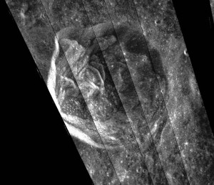
A particularly interesting and unusual feature was imaged by Mini-SAR almost by accident. Because of a timing error, we started a few mapping passes of the south pole early, before the scheduled start at 80° south latitude. Good thing we did! We covered the fresh, spectacular Schrödinger impact basin, on the lunar far side. Schrödinger shows an unusual, keyhole-shaped crater along a long fissure on the basin floor. This crater is surrounded by optically dark material, which has been interpreted as volcanic ash deposits. The new Mini-SAR image shows that this material is also dark in radar reflectivity, exactly what would be expected from a fine-grained, block-free deposit. Thus, our radar images confirm the geological interpretation first derived in 1994 from Clementine images.
The new radar images are not only visually arresting, but they will be extremely useful in unraveling the complex geological history of the Moon as a whole. We are hard at work finishing the calibration of our instrument, which is required in order to make definite statements about the nature of the radar backscatter signature, the tell-tale sign of the presence or absence of water ice. This determination is extremely important and one of our major experimental goals, so you’ll appreciate that we want to get it right and be as certain as we possibly can be before we pronounce on it. I’ll keep you posted on this blog of our progress.
Note: The images described in the this post are now up at the Mini-RF web site.
/https://tf-cmsv2-smithsonianmag-media.s3.amazonaws.com/accounts/headshot/blog_headshot_spudis-300x300.jpg)
/https://tf-cmsv2-smithsonianmag-media.s3.amazonaws.com/accounts/headshot/blog_headshot_spudis-300x300.jpg)