Saab Reinvents Air Traffic Control With a Digital Panorama
With Saab’s new digital panorama, the local air traffic controller may soon go the way of the technical support specialist
/https://tf-cmsv2-smithsonianmag-media.s3.amazonaws.com/filer/20120604021006Saab-rTWR-control-550.jpg)

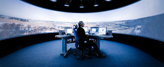
The r-TWR remote air traffic control center (image: Saab)
![]() Every plane that flies over the United States is guided by an elaborate national air traffic control system from the time it pushes off from one gate to the moment it parks at another. The most visible, and most disparaged, element in this system is the local air traffic controller perched in the panoptic towers above airport terminals. While a plane is in sight of an airport these men and women are responsible for almost every aspect of the flight that doesn’t require a pilot’s license. They queue up planes on runways, issue take-off clearance, keep planes at safe distances from on another, and alert pilots to any potentially hazardous weather conditions. Their role is indispensable. Their perches, however, may not be so vital. In fact, if Saab has anything to say about it, the local air traffic controller may soon go the way of the technical support specialist.
Every plane that flies over the United States is guided by an elaborate national air traffic control system from the time it pushes off from one gate to the moment it parks at another. The most visible, and most disparaged, element in this system is the local air traffic controller perched in the panoptic towers above airport terminals. While a plane is in sight of an airport these men and women are responsible for almost every aspect of the flight that doesn’t require a pilot’s license. They queue up planes on runways, issue take-off clearance, keep planes at safe distances from on another, and alert pilots to any potentially hazardous weather conditions. Their role is indispensable. Their perches, however, may not be so vital. In fact, if Saab has anything to say about it, the local air traffic controller may soon go the way of the technical support specialist.

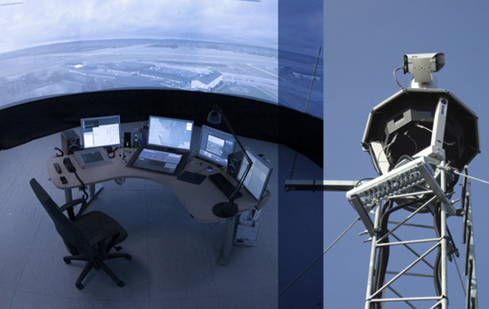
The control center and an r-TWR prototype (image: Saab)
Saab may be best known as an automaker but it also has a vast portfolio that includes advanced aircraft and flight support technologies. The Swedish company has designed advanced guidance systems, standard air traffic control (ATC) towers, mobile ATCs, and now it is making a potentially paradigm-shifting leap with the development of a remote air traffic control tower. The r-TWR was designed to “combine a dynamic use of resources, information sharing and safety enhancement features at a preferred and safe location.” In the r-TWR system, a low-cost mast supports a small platform containing fixed HD cameras that capture a full 360-degree view of an airfield, while a separate remote-control camera offers pan, tilt, and zoom capabilities. Additional tower systems include signal flares, climate sensors, radar systems, and automated hazard detection—all in a relatively small and relatively cheap package. The data collected by the experimental digital tower is live-streamed to an off-site facility where an operator sits at the center of a ring of digital screens displaying live feeds of any r-TWR equipped airport. In many ways, these remote operators have access to more information than their local counterparts. Other than the capabilities to zoom-in with the PTZ camera, the remote system is equipped with infra-red vision, image enhancement, and real-time object tracking software that functions like an augmented reality overlay to assist during low visibility conditions. The r-TWR offers more more reality than reality.
Saab suggests that not only will their system reduce costs, but also increase safety—perhaps by relieving some of the stress from what, as Pushing Tin illustrated, is a notorious high intensity job (“to gain control, you have to lose control”). Plus, with its array of recording devices, the towers can capture and replay any aircraft landing or takeoff, which could assist in the training of controllers and the investigation of aircraft accidents.
The most impressive aspect of the r-TWR is the capability for a remote tower controller to manage multiple airports simultaneously. Teams of coordinated controllers could manage large airports from a centralized warehouse facility (think aircraft hangers full of air traffic controllers instead of planes) or a lone operator could oversee a series of small, regional airports from a single office. With the press of a button, the tower controller is virtually transported to any airfield instantly—or perhaps it’s more accurate to say that the airfield is transported to the tower controller. Imagine: a local controller surrounded by the glowing landscape of Washington Dulles International Airport, guiding planes safely to their gates from the comfort of his office in downtown Cleveland. Such virtual realities aren’t new, of course; video game designers and science fiction writers have been exploring the technology for decades. But the effect of completely immersing a viewer in a foreign landscape has an origin that dates back more than 200 years. Specifically, it brings to mind the 18th and 19th century panorama.

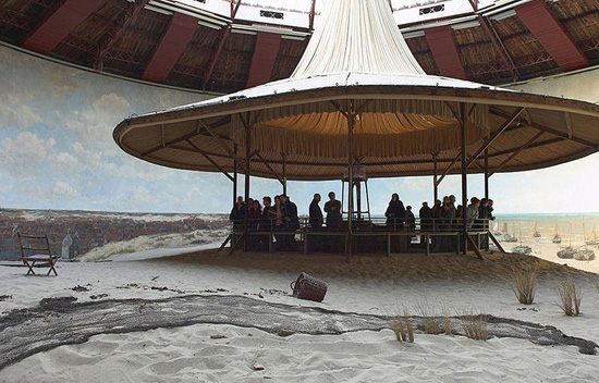
The 1881 Panorama Mesdag in The Hague (image: wikimedia commons)
The panorama, also sometimes known as the cyclorama, was an elaborate construct designed for a single function very similar to the r-TWR: the transportation of a landscape. Though its invention is contested—some attribute its creation to American engineer Robert Fulton (he of steamboat fame)—the panorama was patented by British painter Robert Barker in 1787. It was comprised of an enormous 360-degree realistic landscape painting installed on the interior surface of a cylindrical building and viewed from a carefully located platform at the center of the structure. The paintings might depict idyllic landscapes of far-off lands, recreations of historic battles or even views of another city from the tower of its cathedral. The experience of the panorama was much more profound than the prosaic exhibition of a large painting. It was truly immersive, evoking visceral reactions from many viewers. The entire experience was painstakingly calculated to create the illusion that the visitor was gazing out onto a foreign land; that they had been transported to another time or place.
The technical challenge of creating the paintings alone was immense, but just as important was the building itself. Indeed, the effort that went into creating a panorama could be compared to today’s Hollywood blockbuster; unfortunately very few still exist. They were incredibly complicated to construct and required teams of talented artists, architects, and engineers. To strengthen the naturalistic effect of the painting and the illusion of depth, the orientation of the painting was matched with the building to ensure that the light matched the shadows within the paintings. Not only that, but it was essential that a uniform level of light disperse across the entire painting, thereby creating the illusion that light is actually emanating from the painted landscape. Views had to be constructed to block any outside imagery that would disrupt the illusion. The resulting effect was viewed by some as a testament to man’s mastery of nature. It’s hard to believe now, but at the time the panorama represented a revolutionary change in perception - nothing less than an early form of virtual realty. It implied a sublime dilation of time and space by bringing nature into the heart of the modern metropolis. It represented a commodification of landscapes and history; cities and countrysides became objects of consumption. The panorama was an architectural optical device, a true building-machine.
The standard ATC tower is also an optic building-machine built to serve one incredibly specific function. And the r-TWR is also an optic building-machine—although one without a building. Instead of immersing its centralized viewer in an idyllic landscape, it immerses him in the heart of an airfield. The scale may be much smaller, but there is an urgency to reading the virtual landscape that makes the experience of the r-TWR even more immersive. Things are further complicated when the operator is surrounded by multiple physical landscapes simultaneously, as well as a landscape of data.
While the use of high resolution live video makes remote ATC a technical possibility in the near future, the technology also introduces an entire set of new problems, the greatest of which may be convincing remote operators to trust Saab’s system and to look upon the virtual landscapes with the same careful gaze they now cast out the window of the local tower while mentally keeping each separate reality distinct. But today we’re adopting technological changes into our daily lives faster than at almost any other point in history. We’re training our perception to engage with virtual environments every time we search Google maps. So virtual ATC may not be so far off. The next time you’re stuck on the runway playing Angry Birds, think about directing your scorn away from the invisible overlords in the tower above the airport, and out toward a guy in an office park in Cleveland.
![]() Every plane that flies over the United States is guided by an elaborate national air traffic control system from the time it pushes off from one gate to the moment it parks at another. The most visible, and most disparaged, element in this system is the local air traffic controller perched in the panoptic towers above airport terminals. While a plane is in sight of an airport these men and women are responsible for almost every aspect of the flight that doesn’t require a pilot’s license. They queue up planes on runways, issue take-off clearance, keep planes at safe distances from on another, and alert pilots to any potentially hazardous weather conditions. Their role is indispensable. Their perches, however, may not be so vital. In fact, if Saab has anything to say about it, the local air traffic controller may soon go the way of the technical support specialist.
Every plane that flies over the United States is guided by an elaborate national air traffic control system from the time it pushes off from one gate to the moment it parks at another. The most visible, and most disparaged, element in this system is the local air traffic controller perched in the panoptic towers above airport terminals. While a plane is in sight of an airport these men and women are responsible for almost every aspect of the flight that doesn’t require a pilot’s license. They queue up planes on runways, issue take-off clearance, keep planes at safe distances from on another, and alert pilots to any potentially hazardous weather conditions. Their role is indispensable. Their perches, however, may not be so vital. In fact, if Saab has anything to say about it, the local air traffic controller may soon go the way of the technical support specialist.

The control center and an r-TWR prototype (image: Saab)
Saab may be best known as an automaker but it also has a vast portfolio that includes advanced aircraft and flight support technologies. The Swedish company has designed advanced guidance systems, standard air traffic control (ATC) towers, mobile ATCs, and now it is making a potentially paradigm-shifting leap with the development of a remote air traffic control tower. The r-TWR was designed to “combine a dynamic use of resources, information sharing and safety enhancement features at a preferred and safe location.” In the r-TWR system, a low-cost mast supports a small platform containing fixed HD cameras that capture a full 360-degree view of an airfield, while a separate remote-control camera offers pan, tilt, and zoom capabilities. Additional tower systems include signal flares, climate sensors, radar systems, and automated hazard detection—all in a relatively small and relatively cheap package. The data collected by the experimental digital tower is live-streamed to an off-site facility where an operator sits at the center of a ring of digital screens displaying live feeds of any r-TWR equipped airport. In many ways, these remote operators have access to more information than their local counterparts. Other than the capabilities to zoom-in with the PTZ camera, the remote system is equipped with infra-red vision, image enhancement, and real-time object tracking software that functions like an augmented reality overlay to assist during low visibility conditions. The r-TWR offers more more reality than reality.
Saab suggests that not only will their system reduce costs, but also increase safety—perhaps by relieving some of the stress from what, as Pushing Tin illustrated, is a notorious high intensity job (“to gain control, you have to lose control”). Plus, with its array of recording devices, the towers can capture and replay any aircraft landing or takeoff, which could assist in the training of controllers and the investigation of aircraft accidents.
The most impressive aspect of the r-TWR is the capability for a remote tower controller to manage multiple airports simultaneously. Teams of coordinated controllers could manage large airports from a centralized warehouse facility (think aircraft hangers full of air traffic controllers instead of planes) or a lone operator could oversee a series of small, regional airports from a single office. With the press of a button, the tower controller is virtually transported to any airfield instantly—or perhaps it’s more accurate to say that the airfield is transported to the tower controller. Imagine: a local controller surrounded by the glowing landscape of Washington Dulles International Airport, guiding planes safely to their gates from the comfort of his office in downtown Cleveland. Such virtual realities aren’t new, of course; video game designers and science fiction writers have been exploring the technology for decades. But the effect of completely immersing a viewer in a foreign landscape has an origin that dates back more than 200 years. Specifically, it brings to mind the 18th and 19th century panorama.

The 1881 Panorama Mesdag in The Hague (image: wikimedia commons)
The panorama, also sometimes known as the cyclorama, was an elaborate construct designed for a single function very similar to the r-TWR: the transportation of a landscape. Though its invention is contested—some attribute its creation to American engineer Robert Fulton (he of steamboat fame)—the panorama was patented by British painter Robert Barker in 1787. It was comprised of an enormous 360-degree realistic landscape painting installed on the interior surface of a cylindrical building and viewed from a carefully located platform at the center of the structure. The paintings might depict idyllic landscapes of far-off lands, recreations of historic battles or even views of another city from the tower of its cathedral. The experience of the panorama was much more profound than the prosaic exhibition of a large painting. It was truly immersive, evoking visceral reactions from many viewers. The entire experience was painstakingly calculated to create the illusion that the visitor was gazing out onto a foreign land; that they had been transported to another time or place.
The technical challenge of creating the paintings alone was immense, but just as important was the building itself. Indeed, the effort that went into creating a panorama could be compared to today’s Hollywood blockbuster; unfortunately very few still exist. They were incredibly complicated to construct and required teams of talented artists, architects, and engineers. To strengthen the naturalistic effect of the painting and the illusion of depth, the orientation of the painting was matched with the building to ensure that the light matched the shadows within the paintings. Not only that, but it was essential that a uniform level of light disperse across the entire painting, thereby creating the illusion that light is actually emanating from the painted landscape. Views had to be constructed to block any outside imagery that would disrupt the illusion. The resulting effect was viewed by some as a testament to man’s mastery of nature. It’s hard to believe now, but at the time the panorama represented a revolutionary change in perception - nothing less than an early form of virtual realty. It implied a sublime dilation of time and space by bringing nature into the heart of the modern metropolis. It represented a commodification of landscapes and history; cities and countrysides became objects of consumption. The panorama was an architectural optical device, a true building-machine.
The standard ATC tower is also an optic building-machine built to serve one incredibly specific function. And the r-TWR is also an optic building-machine—although one without a building. Instead of immersing its centralized viewer in an idyllic landscape, it immerses him in the heart of an airfield. The scale may be much smaller, but there is an urgency to reading the virtual landscape that makes the experience of the r-TWR even more immersive. Things are further complicated when the operator is surrounded by multiple physical landscapes simultaneously, as well as a landscape of data.
While the use of high resolution live video makes remote ATC a technical possibility in the near future, the technology also introduces an entire set of new problems, the greatest of which may be convincing remote operators to trust Saab’s system and to look upon the virtual landscapes with the same careful gaze they now cast out the window of the local tower while mentally keeping each separate reality distinct. But today we’re adopting technological changes into our daily lives faster than at almost any other point in history. We’re training our perception to engage with virtual environments every time we search Google maps. So virtual ATC may not be so far off. The next time you’re stuck on the runway playing Angry Birds, think about directing your scorn away from the invisible overlords in the tower above the airport, and out toward a guy in an office park in Cleveland.
/https://tf-cmsv2-smithsonianmag-media.s3.amazonaws.com/accounts/headshot/Jimmy-Stamp-240.jpg)
/https://tf-cmsv2-smithsonianmag-media.s3.amazonaws.com/accounts/headshot/Jimmy-Stamp-240.jpg)