Via Aurelia: The Roman Empire’s Lost Highway
French amateur archaeologist Bruno Tassan fights to preserve a neglected 2,000-year-old ancient interstate in southern Provence
/https://tf-cmsv2-smithsonianmag-media.s3.amazonaws.com/filer/monument-to-emperor-Augustus-631.jpg)
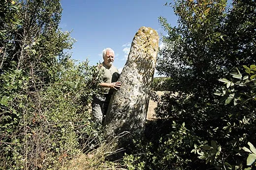
At first glance, it didn't appear that impressive: a worn limestone pillar, six feet high and two feet wide, standing slightly askew beside a country road near the village of Pélissanne in southern France. "A lot of people pass by without knowing what it is," Bruno Tassan, 61, was saying, as he tugged aside dense weeds that had grown over the column since he last inspected it. Tassan was showing me a milliaire, or milestone, one of hundreds planted along the highways of Gaul at the time of the Roman Empire. The inscription had worn away ages ago, but Tassan, a documentary filmmaker and amateur archaeologist, was well versed in the artifact's history. This particular stone, set in place in 3 B.C. during the reign of Augustus, was once a perfect cylinder, set along the nearly 50 miles between Aquae Sextiae (Aix-en-Provence) and Arelate (Arles). "It's one of the last standing," Tassan said.
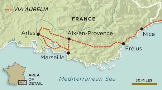
In 12 B.C., Augustus, at the height of his power, commanded his legions to build a highway that would traverse the province of Gallia Narbonensis, or southern Gaul, the last of whose unruly tribes had only recently been subdued. Over the next ten years, surveyors, engineers and construction crews carried off one of antiquity's greatest feats: grading and paving a road from the mountains above the Mediterranean near modern Nice to the Rhone River, 180 miles distant. For nearly four centuries, the Via Aurelia served as the region's principal artery, over which armored legions, charioteers, couriers, traders, government officials and countless others passed. It was the Interstate 95 of its time, complete with rest stops and chariot service stations every 12 to 20 miles—a crucial part of a 62,000-mile road network that extended from the Iberian Peninsula to Asia Minor. Along this paved and finely graded route, Rome maintained its control over far-flung provinces, developed commerce, and disseminated its culture and architecture. But as the empire began its long decline—Rome would fall in the fifth century A.D.—the Via Aurelia began to disintegrate. In contrast, the Via Domitia, an even older Roman route, constructed around 122 B.C. in neighboring Languedoc-Rousillon, has been well preserved, thanks to the intervention of local governments and private interests.
Tassan and a handful of fellow enthusiasts have appointed themselves custodians of the Via Aurelia. During the past few years, he has matched pre-medieval maps to 21st-century aerial photographs, located broken bits of ancient macadam and tried to protect a handful of 2,000-year-old stone walls, sarcophagi, aqueducts, bridges and road markers that point to the engineering sophistication, as well as the reach, of ancient Rome. He has created a Web site devoted to the Via Aurelia, conducted tours for growing numbers of Gaulophiles and hopes to make a documentary about the road.
Tassan has also sought to solve some of the lingering questions about the highway, including how the Romans managed to transport milestones, weighing an average of 4,400 pounds, from rock quarries to road-building sites, often a dozen or so miles away. The Roman legal code in place at the time forbade chariots from carrying loads heavier than 1,082 pounds, the maximum that the vehicles' wooden axles could safely support. "Did they carry them on foot? Did they get a special exemption?" Tassan wondered aloud, as he scrutinized the worn Pélissanne pillar. "It remains," he says, "a mystery."
Experts on the era acknowledge that Tassan has made a unique contribution to ancient Gaulian scholarship. "Everyone knows about the Roman amphitheaters of Arles and Nîmes," says Michel Martin, curator in chief of the library at the Museum of Arles and Ancient Provence. "But the Via Aurelia is a largely lost piece of Roman history. Bruno has done much to keep it alive and to protect the little that's left."
A series of military triumphs paved the way for construction of one of the greatest roads through the empire. During the second century B.C., the region that is now France was a no man's land of warring tribes—a vast stretch of untamed territory lying between Rome and its colony of Hispania (present-day Spain and Portugal). In 125 B.C., citizens of the Greek colony of Massalia (Massillia in Latin), now Marseille, a port since 600 B.C., came under attack from the powerful Salyen tribe, a Celtic confederation whose holdings extended from the upper Rhone to the Alps. Marseille appealed to its nearest power, Rome, for help; in 123 B.C., Roman consul Caius Sextius Calvinus led a force of legionnaires to face the Celts, who were legendary for their ferocity. ("They cut off the heads of enemies slain in battle and attach them to the necks of their horses," the Greek historian Diodorus Siculus wrote of them in the first century B.C.) The Roman legion thrashed the tribe at the Celtic garrison of Entremont, a fortification set on a 1,200-foot-high plateau. The victorious Sextius Calvinus then founded the settlement of Aquae Sextiae on the site of nearby thermal baths, giving the Romans a firm foothold in southern Gaul.
Nearly 20 years later, a Teutonic horde stormed across the Rhine River intent upon seizing Aquae Sextiae. A small force of Roman soldiers lured the invaders toward the town; 3,000 troops then attacked the Teutons from behind, killing 90,000 and capturing 20,000. "By the conditions of the surrender [of the Teutons] three hundred of their married women were to be handed over to the Romans," the Christian scholar Jerome wrote in the fifth century A.D. "When the Teuton matrons heard of this stipulation, they first begged the [Roman] consul that they might be set apart to minister in the temples of Ceres and Venus; and then when they failed to obtain their request and were removed by the [guards], they slew their little children and next morning were all found dead in each other's arms, having strangled themselves in the night."
After the slaughter of the Teutons, Rome consolidated its control over the region. In 62 B.C., the last southern tribe to rise against the empire was subjugated. Julius Caesar established a naval base at Fréjus and founded Arles as a settlement for retired veterans of his Sixth Legion, whom he had led to a series of bloody victories in Asia Minor. When Caesar was assassinated in 44 B.C., his adopted son Octavian, later renamed Augustus, rose to power and made the development of Gallia Narbonensis, his province in southern Gaul, a priority.
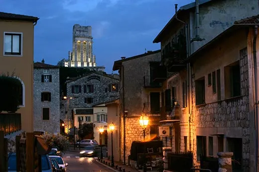
One afternoon I drove through a series of long tunnels north of Nice to La Turbie, a medieval village hugging the hills 1,600 feet above the Mediterranean. Here, where the Alps jut sharply down to the sea, the Romans built a section of their new highway in 12 B.C. Surveyors, engineers and construction crews improved and linked paths that had existed since the time of the Greeks, cleaving passes through the mountains, introducing a sophisticated drainage system, erecting milestones and standardizing the road width to 15 feet—wide enough for two chariots to pass. It wound along the rugged coast to Fréjus, then cut across fertile plains to the Rhone. There, the thoroughfare merged with the Via Domitia, running west through the Spanish Pyrenees. When the two roads met—a convergence comparable to the 1869 linking of the Union Pacific and Central Pacific railroads at Promontory Summit, Utah—Roman control over the Mediterranean basin was cemented.
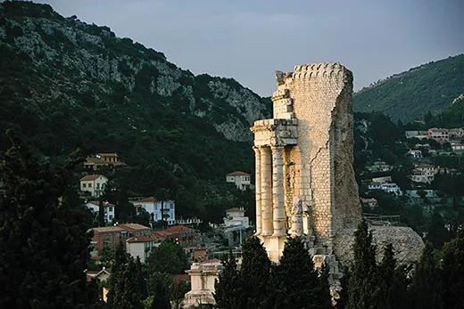
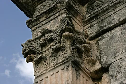
The Romans commemorated the feat with a victory monument at La Turbie, placing, in 7 B.C., a statue of Augustus on a limestone cylinder surrounded by 24 Doric columns. This is what I had come to see: I hiked along a wooded footpath to a hilltop clearing, from which the 115-foot-high Tropaeum, or Trophy, of Augustus—still partially standing after two millennia—dominates the landscape. The emperor's statue has disappeared, and only four of the marble columns that encircled the monument remain intact. One side of the great marble base features reliefs of winged deities flanking a Latin inscription that hails Augustus and the pacification of Gaul. Sheltering myself from a fierce wind, I gazed down the rocky coast of Italy; directly below, the hotels and villas of Monaco glittered at the edge of the turquoise sea. It seemed a fitting place to proclaim Rome's glory.
The Via Julia Augusta, as the highway was initially called, greatly improved overland travel in the empire. Roman legions could shuttle long distances along it at an average speed of almost four miles per hour. Messengers could travel between Arles and Rome, a distance of about 550 miles, in a mere eight days. "The highway was a means for Rome to assert its power," curator Martin told me. "Its real purpose was to move troops and public couriers at the fastest rate possible." By the third century A.D., the highway was known as the Via Aurelia and regarded as an extension of the empire's road from Rome to Pisa, commissioned in 241 B.C. by the censor Caius Aurelius Cotta.
But beginning around A.D. 235, the Via Aurelia fell on hard times. After centuries of political stability, a series of military coups roiled the empire. Roman divisions began turning on one another, the value of currency plummeted, urban renewal ceased and towns and entire districts were abandoned. The empire revived briefly under Diocletian (A.D. 284-305) and Constantine (A.D. 306-37). But in 406, the Rhine froze over and barbarians spilled into Gaul. By the 470s, Arles had surrendered to the Visigoths, opening the whole of Provence to barbarian control. Over the next millennium, roads, bridges, aqueducts and other public works commissioned by Augustus and his successors disintegrated, and the precise route of the Via Aurelia was lost.
It remained largely forgotten until 1508, when Konrad Peutinger, a book collector from Augsburg, in Bavaria, acquired a 22-foot-long medieval scroll portraying a map of the world, from the Atlantic to the mouth of the Ganges, as it existed during the Roman Empire. The map's origins were obscure: a 13th-century monk from Colmar had apparently copied it from a Roman source, possibly a fourth-century A.D. map, or an even older one drawn by Agrippa, aide-de-camp to Augustus, at the dawn of Roman dominance. Whatever its origins, the Table of Peutinger, as it became known—with detailed topography, a rendering of the entire Roman road network, and 550 illustrations of rest stops, Roman amphitheaters and other features along the routes—was widely published. It has offered archaeologists an incomparable opportunity to track down lost vestiges of the Roman world. During the 1960s, in the Italian town of Torre Annunziata, near Pompeii, researchers used the Table of Peutinger to locate and excavate a sumptuous villa from the first century B.C.
I first met Bruno Tassan on a sunny afternoon in June at an outdoor café in Salon-de-Provence, a medieval town 24 miles west of Aix. Burly and suntanned, with a shock of white hair, Tassan grew up in a village near Grenoble. He spent 25 years working as a graphic designer before retiring last summer to pursue a lifelong fascination with ancient Gaul. "When I was 17, my mother gave me a copy of The Civilization of Rome [by French historian Pierre Grimal], and from that point I was hooked," he said. In 1998 he began working on a documentary about another historic route, the ancient Christian pilgrimage trail to Santiago de Compostela in Spain, where the remains of St. James, one of Jesus' Apostles, are said to be buried. To research the project, he set off on a 900-mile journey by foot across southern France and the Pyrenees, following the Roman road network. "I traversed three regions, and in two of them, the Roman road was in good shape," he told me. "The Via Domitia, which crosses two French départements, and the Via Acquitana, which joins Bordeaux and Astorga in Spain, were both well marked and preserved." This was not the case, however, he would learn, for the Via Aurelia.
What was going on, says curator Martin, was a process of urbanization and development around the Côte d'Azur that largely bypassed Languedoc-Rousillon, site of the Via Domitia. "Here you've got more roads being built, more auto routes, and, of course, more destruction," Martin says. "The vestiges of ancient Gaul just aren't as valued as they should be." As development accelerated, more and more of the road was fragmented into sections, stretches of it paved over or subsumed by housing tracts and factories. Rediscovering the surviving traces of the Roman route has been a matter of deduction, legwork and tapping into the historical memory.
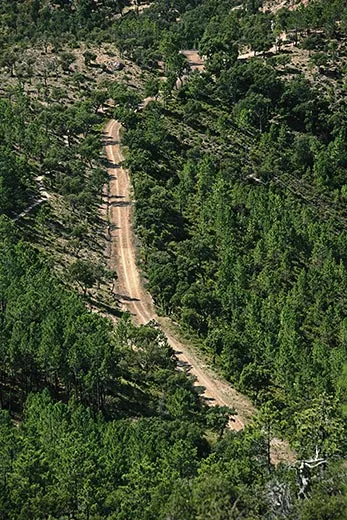
After finishing our espressos, Tassan and I set out by car to inspect remains of the Via Aurelia that he had identified around the town of Salon-de-Provence. We crossed beneath an expressway, traversed an irrigation canal, bounced through fields of grapes, then turned down a narrow dirt road—actually a piece of antiquity—that cut a straight line between an olive orchard and a row of fenced-off villas.
Tassan peered through a barrier of cypress trees into a private garden, pointing out 20-foot-high ruins of a stone wall—what was left of a 2,000-year-old rest house where Via Aurelia travelers could water their horses, repair their chariots and lodge for the night. "Some rest houses had prostitutes as well," Tassan said. "Everything you could want for your journey." (The Table of Peutinger, which functioned as a kind of Michelin Guide of its time, graded guesthouses according to three classifications, basic, moderate and luxury, using a different illustration for each; the cushiest was represented by a rectangular villa with a pool in the middle.) Two guard dogs barked furiously at us, hurling themselves against a fence. Tassan admired the inn's ruins for another few seconds, then said, "Bien, let's get out of here."
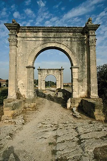
We continued toward the village of Saint-Chamas, turning off the main road from time to time to pick up short stretches of the Via Aurelia—dirt paths, a row of ancient and cracked paving stones, narrow asphalted strips through vineyards. Approaching Saint-Chamas, we came across the ancient road's second-best-preserved vestige—after the Trophy of Augustus: Flavian's Bridge, marked by elegant arches at either end, spanning the Touloubre River. "This is a real treasure," Tassan said. Each arch, built from blocks of tawny limestone, rose about 20 feet high; atop a delicately carved pilaster stood sculptures of two crouching lions. (In 1944, a speeding U.S. Army truck accidentally rammed into one of the arches and knocked it down; American construction teams reassembled it and built a new bridge a few yards downriver.) Tassan pulled out a tape measure, knelt and measured the distance between grooves on the bridge's stone surface. "One point forty-two meters [4.5 feet]," he announced with satisfaction—the standard width of a Roman chariot axle.
The next day, I found Tassan in a blue mood. We had spent the morning touring a construction site near Marseille, where workers, oblivious to the damage they were inflicting, had been laying an oil pipeline across the Via Aurelia's original stones. Now we stood on a hilltop near the medieval village of Mouriès, not far from Arles, looking for traces of the ancient road. Though he was certain it had descended from this crest, he couldn't find a hint of it, not even after a dozen scouting expeditions. "I met an 80-year-old man who told me that when he was small, there was a road that ran through the olive fields here, and he said, ‘that was the Via Aurelia.' But it doesn't exist anymore." It was an all too familiar story. "All these vestiges are in danger of disappearing," Tassan said as we drove down the slope. "Of course, modernization is obligatory, but there should be some effort made to preserve what's left. Why can't it be like the Via Domitia? The milestones were saved, plaques were put up. Here, I'm afraid it's all going."
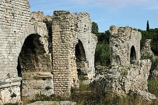
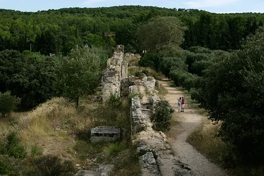
Still, there are the pleasures of discovery and mysteries at every turn. After a few minutes, we stopped outside the rural village of Fontvieille, a few miles northeast of Arles. A double row of great stone arches—the remains of two aqueducts that once ran beside the Via Aurelia—marched in parallel lines through the arid brush. We followed them to the edge of a promontory; below us, golden fields of wheat extended in all directions; the scene looked as it must have at the height of the Roman Empire. Two thousand years ago, water ran down this hill via the aqueduct to a mill, where wheat was ground into flour, then transported along the Via Aurelia to feed the growing population of Gaul. The height of the arches was delicately calibrated to maintain an even flow and pressure—another example of Roman engineering skill.
"You can see that the two aqueducts were built side by side," Tassan pointed out. "One fed the water mill just below, the other provided water to Arles. Now we're going to see something unusual." We followed the second aqueduct as it veered sharply to the right, away from the promontory, through an olive grove. Then, abruptly, it disappeared.
"What happened here?" I asked him.
He shrugged. "It could have been destroyed by the barbarians, to cut off the water supply to Arles," he replied. "But that's just a hypothesis. Nobody knows."
Tassan stood pensively beside the last stone arch for a time. Then, he pulled out his tape measure, got back down on his hands and knees, and began examining one more set of chariot-wheel grooves on the ancient road.
Writer Joshua Hammer is based in Berlin.
Photographer Clay McLachlan works from Paris.
/https://tf-cmsv2-smithsonianmag-media.s3.amazonaws.com/accounts/headshot/Screen_Shot_2021-09-15_at_12.44.05_PM.png)
/https://tf-cmsv2-smithsonianmag-media.s3.amazonaws.com/accounts/headshot/Screen_Shot_2021-09-15_at_12.44.05_PM.png)