New Satellite Network Launching This Year Aims to Improve Weather Forecasting
With a network of compact, low-cost weather satellites with smartphone-like internals, startup Spire plans to make future forecasts a lot more reliable
/https://tf-cmsv2-smithsonianmag-media.s3.amazonaws.com/filer/59/60/5960322e-c941-44b4-bcae-22121e13c64e/spire_satellite_frame.jpg)
Thanks to smart devices, GPS navigation and wearable sensors, we’ve become accustomed to accuracy in many aspects of our modern lives. But weather forecasts are still often imprecise, as was abundantly clear to anyone affected by winter storm Juno last week. New York City shut down in preparation for a historic blizzard, but the storm shifted further east than expected, dumping most of its precipitation on Boston and other parts of New England.
Soon, though, such high-profile (and costly) forecasting blunders may be a relic of the past. Beginning this year, a Silicon Valley startup called Spire is set to launch a network of small satellites aimed at improving and modernizing weather forecasting on a few key fronts.
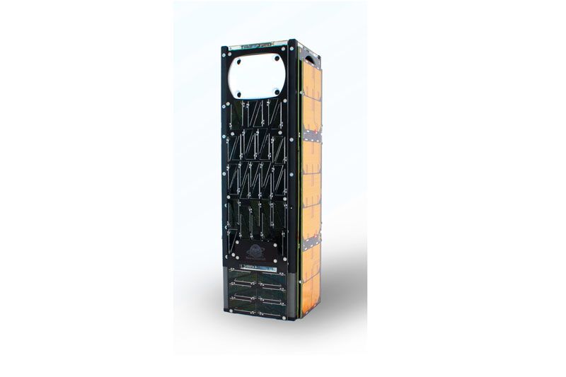
The company plans to first increase the number of available daily satellite weather data points five-fold by the end of 2016, from 2,000 to 10,000, using a fleet of custom-built, wine-bottle-sized satellites. Twenty of the company’s devices are slated to launch by the end of the year, with more expected to follow. Spire isn’t focused on a specific number of satellites, but rather aims to give meteorologists 100 times the current satellite weather data by the end of 2017, in part by covering areas so far neglected by existing weather satellites.
“Once you dive into forecasting, the cynicism toward weather forecasters turns into utter admiration,” says Spire’s CEO, Peter Platzer, “because you realize how accurate those people have become with [very little] data.”

Many active satellites are car-sized, overdue for decommission and, according to Platzer, making do with the computing power of the average early 90s desktop. Goverments launched these early weather satellites, largely due to the massive initial expense. But, the United States and European countries, most likely stifled by bureaucracy and budget constraints, haven't kept the oribiting technology current.
While government red tape has held weather technology back, shifting to a profit-driven model could push it forward dramatically. Spire’s satellites take advantage of modern miniaturization and smartphone-like tech, making them more capable, upgradable via software and inexpensive enough to regularly replace, so the network can keep pace with modern advancements.
Spire’s satellites will also make use of the existing network of GPS satellites by gleaning data from their transmissions. Spire's devices monitor the microwaves GPS satellites send out, which pick up precise data about temperature, wind speed and moisture as they travel through the atmosphere. This process, called GPS Radio Occultation, has been tested extensively by NASA and the Taiwanese government.
“Because we don’t have to produce those beams ourselves,” says Platzer, “we can build and leverage much, much smaller satellites, and build far more of them.”
The scale of Spire’s eventual network is also part of what makes it appealing. Not only will several satellites provide more frequent readings, but there will also be a level of redundancy, so that should one or two of the devices fail for any reason, the network won’t be significantly compromised. And, Platzer says, the number of satellites will allow the company to cover large parts of the Earth, particularly over the open ocean and sparsely populated regions, which today aren’t regularly monitored by the limited number of existing weather satellites.
Launching a network of dozens of spacecraft seems like about the most ambitious goal any startup could tackle. But Platzer seems to have the requisite resume. An Austrian-born physicist who trained at CERN and the Max Plank Institute, he later attended Harvard Business School, and worked in finance and consulting for a decade before turning his interest back toward space, interning at NASA’s Ames Space Portal. Platzer started Spire in 2012, under its initial name, NanoSatisfi, to focus on compact, low-cost satellites, also known as CubeSats.
Since then, the company has raised at least $29 million in funding according to the Wall Street Journal and launched several small satellites in 2014, including a prototype of the weather satellites they’ll be using for the eventual network.
As for how Spire hopes to turn a profit on their satellite network, Platzer says that’s pretty straightforward. They’ll be selling data as a service to companies, governments and universities, just like several other major tech firms. But while companies like Google and Facebook generate data about billions of people, Spire will be gathering and selling data that affects everyone.
“Weather impacts a third of the global economy,” says Platzer. “Close to six trillion dollars of U.S. GDP are impacted by the weather. So there’s no shortage of people who would like to have significantly better weather prediction.”
While the company is focusing on weather for now, Platzer says their satellites can also be used to track ships and planes over the ocean, to combat piracy and illegal fishing, as well as to gather more precise climate change data.
Of course, in a post-Edward Snowden world where corporations and governments are amassing huge amounts of information about us, people have a right to be at least somewhat wary about yet another high-tech tool that can be used for tracking. But Platzer points out that their satellites don’t take pictures and aren’t used for tracking cars or personal vehicles, and so shouldn't raise any privacy concerns.
“We look where no one else is looking and where no one lives,” says Platzer, “and we provide something that impacts every single person.”
/https://tf-cmsv2-smithsonianmag-media.s3.amazonaws.com/accounts/headshot/unnamed.jpg)
/https://tf-cmsv2-smithsonianmag-media.s3.amazonaws.com/accounts/headshot/unnamed.jpg)