Scorchingly Hot 2012 Riddled With Extreme Weather
Drought, heatwaves, cyclones—even a tornado in Hawaii—mark last year as one filled with record-breaking severe weather
![]()

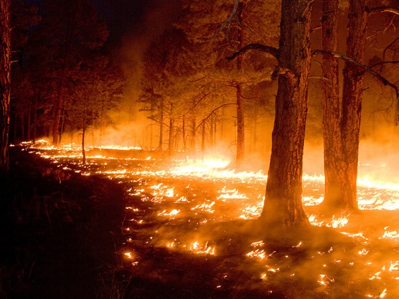
New Mexico’s 2012 Gila Wildfire was the largest in the state’s history. By Gila Forest
Earlier this week we learned that 2012 ranks as the hottest year on record, with an average temperature more than three degrees higher than the average for the 20th century. But a deeper look into the National Oceanic and Atmospheric Administration’s (NOAA) annual climate report shows that, in the United States, 2012 was also riddled with extreme weather events.
In fact, it was the second-most extreme year on record for weather, according to the U.S. Climate Extremes Index, which analyzes variations in precipitation, temperatures and land-falling tropical cyclones. There was a frenzy of events such as drought, heat waves, flooding, wildfires and tornadoes, many of which were more severe than in years past. And we also saw exotics like the derecho, a powerful thunderstorm cluster, and Sandy, dubbed a Frankenstorm in the press and a post-tropical cyclone by NOAA. Overall, the meterological spikes were almost twice the average. Several unusual occurrences stand out:
- Drought: Dry conditions were the norm from the get-go in 2012. The central and southern Rockies received less than half the usual amount of snow, and nationally the winter season had the third-smallest snow cover. To make matters worse, spring showers never made an appearance. Precipitation was 95 percent that of the spring-time average for the 20th century. As the year went on, more than 60 percent of the nation was plagued by a drought that peaked in intensity in July. The NOAA report noted that the conditions were “comparable to the drought episodes of the 1950s.”
- Blistering heat: The fourth-warmest winter on record was followed by the warmest March, the forth-warmest April and the second-warmest May. Overall, spring 2012 was two degrees hotter than any spring before it. These balmy conditions kickstarted an early growing season, which exacerbated the drought by depleting water from the soil earlier in the year than usual. July’s average temperature of 76.9 Fahrenheit made it the hottest month ever recorded for the contiguous U.S. and helped contribute to another record: the second-warmest summer. A third of Americans endured 100-degree-plus temperatures for 10 days or more. All told, every state had an above-average annual temperature and 356 all-time record high maximum temperatures were tied or broken in 2012.
- Mega wildfires: Dry conditions primed the nation for wildfires by creating fuel sources in dried-out vegetation. The heat then encouraged combustion. Some fires were sparked by natural phenomena (lightning), others had manmade sources (cigarettes, campfires, arson). Flames charred a total of 9.1 million acres nationwide, decimating an area the size of Massachusetts and Connecticut combined. New Mexico was torched by the biggest wildfire in its history and Colorado experienced its most costly wildfire. The most severe fire month nationally was August, when upward of 3.6 million acres went up in flames–more than any single month since 2000.
- Tropical cyclones: These storms suck heat from the ocean and then unleash that heat near the storm’s center. A total of 19 tropical cyclones touched down in the U.S. in 2012, making it the third-most-active tropical cyclone season on record. The most infamous were Isaac, which pummeled Louisiana with 106-mph gusts of wind, bringing Katrina flashbacks, and Sandy, which made landfall near Atlantic City, N.J.. Its 80-mph winds created record storm surges that resulted in 131 fatalities and left eight million people without power.
- Derecho: A band of thunderstorms packing tornado-force power, the derecho usually follows a straight path heading in one direction. To earn the National Weather Service’s derecho designation, the storms’ winds must reach at least 58 mph. Lower Michigan was whipped by a 130-mph derecho in 1998; the one that steamrolled the country from Indiana to Maryland in June was tamer, bringing winds of up to 80 mph. According to NOAA, derechos tend to occur on the heels of heat waves.
- Fewer, but severe, tornadoes: Although the number of tornadoes plummeted in 2012, reaching the lowest levels since 2002, the storms that did strike were fierce. A surge of 80 early-March tornadoes that swept through the Midwest caused 42 deaths. One that ravaged Indiana with winds between 166 and 200 mph ranked as a four on the Enhanced Fujita Scale of tornado strength, placing it in the top two percent of all tornadoes strength-wise.
- Storm flukes: Hawaii was struck by an anomalous tornado when a water spout churning off the coast of Oahua made landfall. True it was classified at zero on the Enhanced Fujita Scale, but its 60- to 70-mph winds reportedly destroyed several buildings and delivered another record: a grapefruit-sized hailstone, the biggest ever to hit the Hawaiian Islands.
What does this all mean in terms of the impact of climate change on weather? Scientists don’t exactly agree. According to some, we shouldn’t read too much into the statistics. “Natural variability continues to dominate the occurrence of extreme weather events,” atmospheric scientist Judith A. Curry of the Georgia Institute of Technology told The Washington Post, adding that the global average temperature for 2012 will not top the charts, but rather will be the eighth-highest on record.
Gerald Meehl, a senior scientist at the National Center for Atmospheric Research, is in the opposing camp. “By adding just a little bit more carbon dioxide to the climate, it makes things a little bit warmer and shifts the odds toward these more extreme events,” Arndt told National Geographic. “What was once a rare event will become less rare.”