These Bright Webs Depict Flight Patterns Around Major Airports
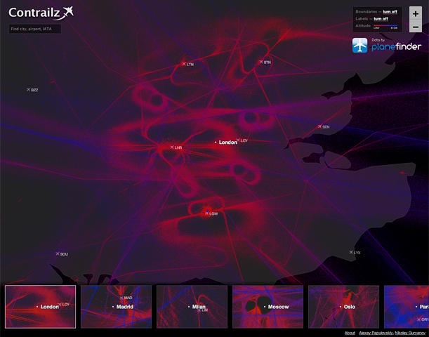
Software engineer Alexey Papulovskiy has built Contrailz, a site that generates visuals of flight data over cities around the world
London. Image courtesy of Contrailz.
Software engineer Alexey Papulovskiy has flown more in the past two years than he had in his entire life. Since moving to Moscow, he has taken trips to Kiev, Saint Petersburg, Dublin, London and Istanbul, among other cities, and in the process, he has become enamored with airports.

Amsterdam. Image courtesy of Contrailz.
“Each of them is a complex of grand engineering tasks: queue management, baggage transportation from the check-in point to the specific plane, aircraft services,” he says. “It’s a kind of engineering magic.”

Paris. Image courtesy of Contrailz.
The more Papulovskiy familiarized himself with flight paths between cities and pilots’ procedures for take-offs and landings, the more he wanted to devise a way to visualize flight data. Last fall, from September 30 to October 29, he collected the flight levels of commercial and private planes traveling in North America, South America, Europe and parts of Asia from PlaneFinder.net. At the end of the month, Papulovskiy had about one billion data points.
Instead of connecting the points over a map, as digital artists Aaron Koblin and Mick West have done with similar projects, the software engineer left the data points as dots. The result is a clever digital take on pointillism. On a black background, he plots high altitudes in blue and low altitudes in red. Together, they resemble the interweaving strands of a tent caterpillar’s web. “Maybe later I’ll try to show planes’ speeds,” he says.

Dubai. Image courtesy of Contrailz.
With Contrailz, the interactive tool Papulovskiy has built, users can plug in a specific airport or city and the site will generate the appropriate image. There are some interesting finds within the visualizations. One can see the prohibited airspace over Moscow and southern Nevada’s Area 51, for instance. The images also make clear multi-lane “highways” near Vienna, notes Papulovskiy, and the impressive choreography arranged by air traffic control over cities like London and New York with multiple airports. Then, of course, there is the aesthetic experience.

Moscow. Image courtesy of Contrailz.
“These flight paths are a kind of art,” says Papulovskiy. He compares the cities, roads and other networks humans mark the Earth with to the complexity of ant hills and meandering rivers—what he calls the “art in nature.”

Barcelona. Image courtesy of Contrailz.
“I hope these images remind people that there are a lot of beautiful things around and above us,” he adds, “though we never think about them.”
/https://tf-cmsv2-smithsonianmag-media.s3.amazonaws.com/accounts/headshot/megan.png)

/https://tf-cmsv2-smithsonianmag-media.s3.amazonaws.com/accounts/headshot/megan.png)