Why the Nepal Earthquake Was Especially Bad for Cultural Sites
The major quake sparked a resonance in the basin that made taller buildings more likely to topple
/https://tf-cmsv2-smithsonianmag-media.s3.amazonaws.com/filer/6c/eb/6ceb6a7b-bc0c-4c2f-be66-ed80094972a0/42-74037499.jpg)
The magnitude-7.8 earthquake that struck Nepal on April 25 was devastating for the people of that region—more than 8,000 died and many monumental cultural sites crumbled. Oddly, though, smaller buildings tended to survive the shaking, and now scientists may know why. The quake put the basin surrounding the capital Kathmandu into a resonance that made taller buildings more likely to fall.
“The death toll is certainly a tragedy but far less than what I would have expected for such an earthquake so close to Kathmandu," says lead author Jean-Philippe Avouac, an earthquake scientist at Caltech and the University of Cambridge. The epicenter of the quake was about 50 miles from the Nepalese capital, so "given the dense population and vulnerable buildings, I was prepared for at least ten times more casualties,” Avouac says.
Instead, less than one percent of the city’s structures collapsed during the quake, and shorter dwellings in the capital suffered far less damage than might be expected. Taller structures, including many cultural sites, did not fare so well. Patan Durbar Square and Hanuman Dhoka, both in Kathmandu, as well as the nearby historic city of Bhaktapur were almost fully destroyed, UNESCO reported in the days afterward.
Nepal sits where the Indian and Eurasian continental plates meet. The Indian subcontinent is slowing moving north, and its edge dives beneath the Eurasian Plate, pushing up the Himalayas. Earthquakes are common throughout the region, and strong quakes have hit Nepal in the past. Some of the sites that collapsed in April had survived these previous events. For instance, in 1934, the region experienced an earthquake estimated to be magnitude 8.1 to 8.4. A fifth of the capital’s buildings collapsed in that event, but the 200-foot-tall Dharahara tower largely survived.
Avouac and his colleagues used information from a series of continuous GPS stations, along with satellite data, to model the April 25 quake. Reporting this week in Science, they found that the event focused seismic energy toward Kathmandu. The seismic pulse had a smooth onset and lasted only six to seven seconds, but it started a resonance in the basin that produced violent shaking, similar to the way certain musical pitches can set glass vibrating. The geologic oscillations were just right to topple taller structures but leave shorter ones intact.

This is the first time that a large continental earthquake occurred beneath this type of GPS monitoring network, and in this case the stations were close to each other and encompassed the entire rupture area. This kind of data hasn’t been available for previous earthquakes, so scientists can’t say whether the quake’s characteristics were totally unique compared to past events.
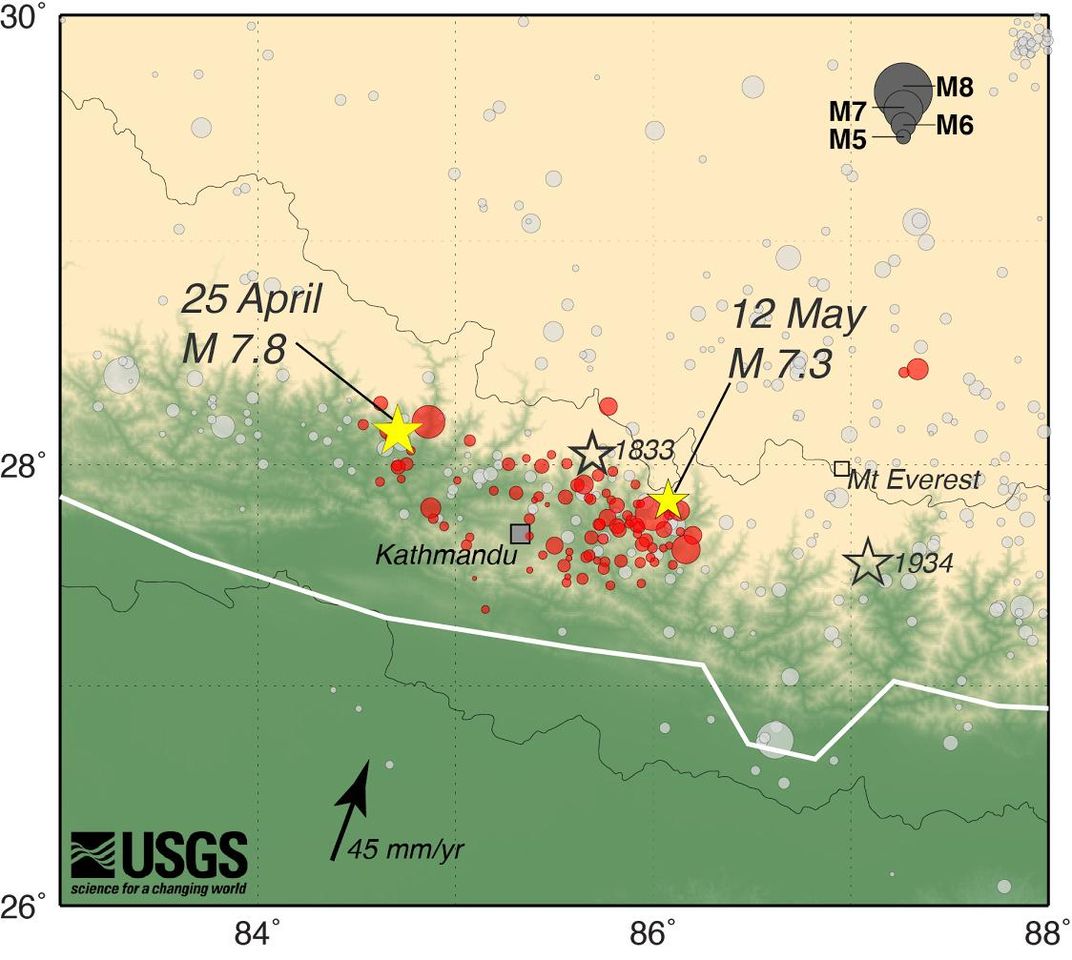
Avouac and another set of colleagues did look to the future by examining how the earthquake affected the underlying fault. They found that the initial quake and a magnitude-7.3 aftershock on May 12 unzipped the eastward portion of the Main Himalayan Thrust fault and released seismic stress that had been pent up in that segment of the fault. The area east of Kathmandu is therefore unlikely to experience another large quake of magnitude 7.5 or higher in the near future, the researchers report in Nature Geoscience.
However, the study confirms warnings made in the days after the April 25 quake that the western section of the fault still poses a serious hazard. The last large earthquake in that section of the fault occurred in 1505. It's unclear just how big a future quake could be, but the researchers note that in the past, the region has produced major earthquakes greater than magnitude 8.5.
/https://tf-cmsv2-smithsonianmag-media.s3.amazonaws.com/accounts/headshot/Sarah-Zielinski-240.jpg)
/https://tf-cmsv2-smithsonianmag-media.s3.amazonaws.com/accounts/headshot/Sarah-Zielinski-240.jpg)