Take a Trip Around Pluto and Charon With These New Animations
Two years after its fly-by, NASA releases maps and videos made with data from New Horizons
Two years ago this month, New Horizons zipped by the dwarf planet Pluto, giving humanity its first close-up look at the icy world. Though the fly-by may be long over, scientists are still working through the trove of data beamed back during the venture. And to mark the anniversary, NASA released a new series of maps and videos to explore these distant bodies.
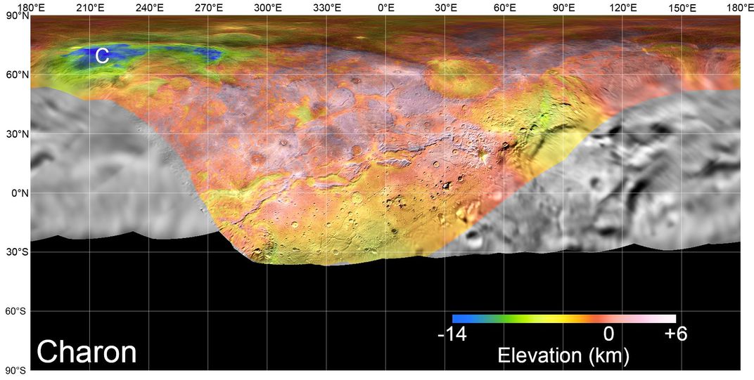
A 3D fly-over of Pluto, animated with data collected by New Horizons, takes viewers over some of the dwarf planet's most iconic features, reports Rae Paoletta for Gizmodo, including the large nitrogen ice plain Sputnik Planitia. A fly-over of Charon, Pluto's largest moon, shows its deep canyon Serenity Chasma (named after the spaceship in the Firefly series) and other fancifully named features.

The New Horizons team also released a series of detailed topographical maps of Pluto and Charon. Two high-tech sensing devices on the satellite, the Long-Range Reconnaissance Imager and the Multispectral Visible Imaging Camera, allowed scientists to measure the precise elevations of various features on the two bodies from still photographs, reports Doris Elin Salazar for Space.com. Some of the features captured by the maps include ice volcanoes, as well as mountains and craters.
“The complexity of the Pluto system—from its geology to its satellite system to its atmosphere—has been beyond our wildest imagination,” said Alan Stern, New Horizons principal investigator in a statement. “Everywhere we turn are new mysteries. These new maps from the landmark exploration of Pluto by NASA’s New Horizons mission in 2015 will help unravel these mysteries and are for everyone to enjoy.”
Since its Plutonian encounter, New Horizons has been on course to explore the Kuiper Belt, and is now set to fly by a small object more than 1 billion miles past Pluto in 2019.

