Think Apple Maps Are Bad? These Cartographics Blunders Were Way Worse
If you think Apple messed up big time, think again. The history of map making is full of far worse blunders

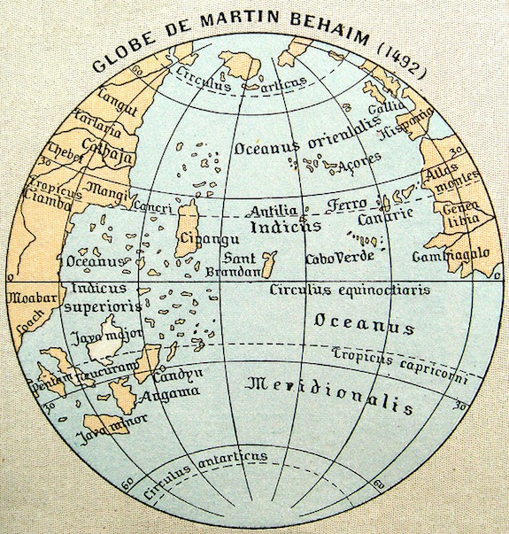
Image: Martin Behaim 1492
You’ve probably heard, at this point, about how bad Apple Maps were. We won’t really go into that. But if you think Apple messed up big time, think again. The history of map making is full of far worse blunders.
The Wall Street Journal chronicled some of them. Take Ptolemy’s map from around 194 B.C.:
Ptolemy could not resist filling blanks on his maps with theoretical conceptions, something that plagues exploration to this day. The Indian Ocean was displayed as a large sea surrounded by land, while many of his measurements of longitude (something that was very hard to measure accurately until John Harrison’s timepiece won a famous competition in the 18th century) were way off beam. The biggest miscalculation of all, the longitudinal position of the Far East, would eventually suggest to Columbus that Japan could be reached by sailing West from Europe.
Or the mappae mundi that hung on the walls of Churches in the 11th century:
The maps contained places we seldom see on modern charts these days—Paradise, for instance, and fiery Hell—and the sort of bestiary and mythical imagery one might expect to find in Tolkien’s Middle-earth. We can marvel at the mythical bison-like Bonacon, for example, spreading his acidic bodily waste over Turkey, and the Sciapod, a people whose enormously swollen feet were said to make fine sun-shields.
Then explorers filled in some parts of the map like the Americas. In their new maps, California was an island disconnected from the West Coast of the United States. When sailors tried to sail around California, they failed and were quite confused. But the map didn’t change for years.
And then there are the Mountains of Kong—a mountain range stretching across Africa on maps from the 19th century. The Wall Street Journal writes:
The problem was, he had relied on erroneous reports from harried explorers and his own imagined distant sightings. The Mountains of Kong didn’t actually exist, but like an unreliable Wikipedia entry that appears in a million college essays, the range was reproduced on maps by cartographers who should have known better. It was almost a century before an enterprising Frenchman actually traveled to the site in 1889 and found that there were hardly even any hills there. As late as 1890, the Mountains of Kong still featured in a Rand McNally map of Africa.
Apple Maps might have duplicated the Senkaku Islands or sent you to the wrong Starbucks, but at least it never invented entire mountain ranges.
More from Smithsonian.com:
You Can Come Out of Your House Now: Google Maps Is Back on the iPhone
An In-Depth Look At the Waldseemüller map
/https://tf-cmsv2-smithsonianmag-media.s3.amazonaws.com/accounts/headshot/Rose-Eveleth-240.jpg)
/https://tf-cmsv2-smithsonianmag-media.s3.amazonaws.com/accounts/headshot/Rose-Eveleth-240.jpg)